


After a cold and gray summer in the San Francisco Bay Area, the weather for tonight's flight is hot, so hot that record high temperatures were set today for several California cities. The goal is to complete back-to-back cross-country flights to meet commercial pilot requirements: One flight during the day, one at night, both a minimum of 2 hours with a straight-line distance of at least 100 nautical miles between departure and destination. Along the way I'll test the commercial candidate's ability to navigate with VORs, GPS, dead reckoning, and pilotage. The unstated goal, as is the case anytime pilots decide to go flying, will be to savor the joy of flight, even if the air is hot and dry.
These back-to-back cross-country flights are not new to me and I have a few possible destinations up my sleeve that will meet the distance and time requirements. For tonight, we'll fly to Harris Ranch, near Coalinga, California, at the Southern end of the San Joaquin Valley. Harris Ranch is more than 100 miles from Oakland. We can easily get there in less than 2 hours, so the solution is to give the pilot a diversion and there are many airports from which to choose. After diverting, we'll land at Harris Ranch, buy some fuel, sit in the air conditioned restaurant, have a bite to eat, if necessary we'll wait for official night to begin, and hope for a cooler two-hour return flight.
A luxury on long flights is the ample opportunity for a pilot to demonstrate their skills in a relaxed, slower paced setting. And since we'll be doing two cross-country flights with a break in between, the candidate gets a chance to integrate what he learns on the trip down and apply it on the trip back. Learning is a change in behavior ... A flight instructor candidate will be riding along in the back seat, observing, taking some photos and videos, and sharing the fun. The surface temperature at Oakland is a sizzling 34˚C, the air is still and bone dry, and it will be a thousand years until the winter rains come.
The aircraft for tonight's flight is a well-equipped, late-model G1000 Cessna 172 with a nice, accurate autopilot. That should help relieve the tedium of the long flight. We depart Oakland, turn to the East and begin a slow climb. Norcal Approach eventually clears us up to 5,500 feet and the outside air temperature gradually drops to 28˚C. That's over twenty degrees warmer than the standard temperature for this altitude, but the air flowing out the tiny cabin air vents feels surprisingly cool.
The initial route takes us over Tracy, California and then we begin some IFR flying (I Follow Roads) along Victor I-5, a major commercial freeway that runs the length of the state. It's hard to get lost following a big swath of pavement and there are several small airports along the route, just in case we unexpectedly need one.
Dead ahead is the Lemoore Military Operations Area, which brings up the first topic of discussion: Is the Lemoore MOA active? The pilot had planned a different route than what I've asked him to fly. He planned the trip primarily using IFR charts and confesses a dislike for VFR charts, but now he consults his sectional and finds the Lemoore MOA is listed as active. Just to be sure, he asks the approach controller who tells us the MOA is cold. Good to know that in the entire state of California, something is cold.
As we near Los Banos, it's time to divert and the fun begins. I take away the GPS navigational information and after drawing a course line, measuring the magnetic course and distance, estimating the time en route and fuel required, another lesson is learned: On long trips it sure helps to have a big plotter instead of one of those small, compact rulers. Flying along the new course using dead reckoning and pilotage distracts us from the heat. The winds aloft are negligible, the ride is smooth, and as the sun sinks to the horizon the Sierra Madre are bathed in a golden light.
The pilot locates and identifies various airports along the way, Madera, Fresno, Reedly. During the descent to Woodlake, California, the new destination, the temperature climbs. The Sierra foothills shimmer in the twilight and seem to be glowing from within. Peaceful orchards and farmland are slipping by underneath us, lush and green in spite of the heat. The life of a professional flight instructor is fraught with difficulties, but this view makes the trials and imperfections melt away. A little voice in my head says, "Fix these sights in your memory and they will give you solace in the future."
Gliding closer to the runway, we can see that the pavement appears freshly resurfaced. I recall landing here in a Caravan during 135 indoc training, doing a 180 and back-taxiing on the poorly surfaced runway because the parallel taxiway was even worse: A trail of broken asphalt and potholes. Back to the present, the Skyhawk seemingly hovering in the landing flare, I glance to the left and see a familiar wooden building. This unassuming structure houses something out of a time warp, the archetypal $100 hamburger restaurant straight out of a pilot's dream. I had a grilled cheese sandwich here years ago and the check airman had a cheeseburger. Alas, the restaurant is not open at this hour and after a touch and go, we depart straight-out for Harris Ranch.
My half-liter stainless steel water bottle that was filled with ice cubes and cold water is now empty. My stomach is growling and I didn't pack any snacks. The pilot neglected to bring any water at all, which spawns a quick discussion of aeromedical factors. In hot weather the body loses water fast and with low relative humidity perspiration dries so quickly you may not realize you're dehydrated until the symptoms start: Headache, dizziness, dry mouth, difficulty concentrating. Not to worry, we'll soon be ensconced in cool, air-conditioned comfort at the Harris Ranch restaurant.
On the way we briefly receive flight following from Lemoore Approach and the controller is busy talking to what I assume is a squadron of F-18 Hornets. Nothing appears on my traffic detector and I can only conclude their transponders are not turned on. Told to squawk VFR, the descent to Harris Ranch commences and the narrow, brightly lit runway comes into view next to I-5 and its endless stream of truck and automobile traffic. Turning final, something unexpected happens: The runway lights begin to flash on and off at regular intervals. We attempt to click the mic (the aviation equivalent of The Clapper), but the lights go off and stay off. We live in an imperfect world and it's time for a real-life diversion.
In the go-around there's a low-fuel annunciation, most likely due to the climb attitude combined with a somewhat low fuel quantity. We have at least an hour's worth of fuel, but a flashing yellow annunciator isn't soothing. The pilot chooses to divert to nearby New Coalinga where self-service fuel should be available. Then the sinking realization: No cold drinks, no snacks, no air-conditioned restaurant. The pilot needs water and I'm hungry. Another lesson relearned - something about Plan B ...
New Coalinga is deserted and save a few hangars, the only signs of any aviation activity whatsoever is a single Cessna, tied down on the ramp. The air is still and warm, but surprisingly, not that hot. And there's a smell in the air you'd instantly recognize if you've ever driven past Coalinga: We're downwind from a huge cattle stockyard. No matter, the fuel pump is functioning and there is a pilot's lounge/briefing room in a mobile-home style building just beyond the fence. A dog is barking somewhere in the darkness that has settled on the airport and then a light comes on.
The airport manager lives in the other half of the mobile home. He appears, dressed for the weather, barefoot, wearing jeans and sans t-shirt. I apologize if we've disturbed his evening. He says it's fine, turns on the lights for us and shows us what's available. There's no food to be had, but there is a vending machine with cold soft drinks. The CFI candidate riding along takes some pictures and the sounds his digital camera makes are all we hear.
I bring up FltPlan on my iPhone, locate Harris Ranch and give them a call. I get the hotel receptionist and describe the problem with the runway lights. I'm not sure the receptionist understands the nuances of runway lighting, but she assures me they'll look into it.
After departing, I ask the pilot to head toward Madera, he programs the GPS and contacts Lemoore Approach. We get flight following through the MOA, which seems to be active and the runway lights at Harris Ranch are working again. The controller is still talking to a bunch of Hornets, but we can only hear one side of the conversation since we're using a VHF transceiver and the F-18s are using high frequency transceivers. We see some flashing red beacons, but my traffic detector insists we're all alone.
When I was a kid and we were reaching the end of a road trip, I recall how a peculiar silence would engulf the car and make every small rattle, click, or bump in the road seem significant. That same feeling overtakes me as we cross over Tracy and turn toward San Francisco Bay. The pilot elects to fly a practice ILS approach and while Oakland's North Field is quiet, the South Field is humming with activity. A single tower controller is working all the frequencies for the entire airport: Tower, Ground, and Clearance Delivery. Whatever gets you through the night ...
The North Field is eerily quiet and the temperature is actually warmer here than it was at New Coalinga. With the plane back in the hangar, we're back to business cleaning all the leading edges and the windshield. A cynical Larry Summers famously claimed "In the history of the world, no one has ever washed a rental car." The same cannot be said of rental aircraft and Mr. Summers would get some serious remedial training if he were ever to fly with me. After a quick debrief and signing of the logbook, this evening's two cross-country flights are in the books.
Flying focuses our minds, offer tangible goals, tests physical and intellectual skills. Yet while we're focused on our flying performance, we're also taking in sights and sensations that only a flying animal can know and appreciate. The next time you go flying, bring a friend or a loved one, and drink in the world from above. May the joys you experience stay fixed in your mind and provide comfort as you make your way through this perfectly imperfect world.
Showing posts with label non-towered ops. Show all posts
Showing posts with label non-towered ops. Show all posts
Saturday, October 2, 2010
Wednesday, July 29, 2009
Bermuda Triangle

Pilots often think the real work surrounding flying begins once they are airborne, probably because taxiing for takeoff or after landing usually doesn't seem very demanding, interesting, or dangerous. Some of my more harrowing moments in airplanes have occurred during ground operations and the years have taught me that planning, organization, and situational awareness on the ground during single pilot operations can be just as critical as when you're airborne.
The FAA, recognizing the importance of safe ground operations, has published AC 91-73A: Part 91 and Part 135 Single-Pilot Procedures During Taxi Operations, which divides single-pilot ground operations into planning, situational awareness, written taxi instructions, radio communication, and finally taxiing itself. It's a pretty good read, especially for seasoned pilots who may have become a little complacent, and it got me thinking of some of the more memorable experiences I've had while I was just taxiing.
Standardization
The AC suggests that pilots use SOPs (standard operating procedures) which should be introduced during initial training, applied during each flight, and evaluated during recurrent training. The problem is that GA pilots whose initial training was accomplished under part 61 often have little exposure to SOPs, other than their instructor's biases and what they see other pilots do. My wife says that dogs mostly learn bad habits from other dogs and the same could be said for pilots, so here are some recommended practices for single pilot ground operations.


Approach Briefing
Post-Flight & Good Night
The AC suggests that pilots use SOPs (standard operating procedures) which should be introduced during initial training, applied during each flight, and evaluated during recurrent training. The problem is that GA pilots whose initial training was accomplished under part 61 often have little exposure to SOPs, other than their instructor's biases and what they see other pilots do. My wife says that dogs mostly learn bad habits from other dogs and the same could be said for pilots, so here are some recommended practices for single pilot ground operations.
- Get a briefing and check for NOTAMs
- Write down taxi instructions
- Have the airport diagram out and refer to it
- Avoid distractions during taxi, like programming the GPS
- If reading a checklist, hold it up so your peripheral vision is outside
- If confused about your taxi clearance, get clarification
- Don't be bashful about asking for progressive taxi instructions
- Expect the unexpected at non-towered airports, even on the ground
Have a Plan
Before calling for taxi, especially at an unfamiliar airport, it's good to review the airport diagram and mark any NOTAMs for taxiway or runway closures or other changes. Listen to the surface weather (ATIS, ASOS, or AWOS) to determine which runways are in use and look at the airport diagram and estimate the best route to the departure runway. That way when you get your taxi clearance, you'll more likely actually understand it. Jeppesen, for their part, marks hot spots on their airport diagrams and even includes some description of why the areas require special attention.
At larger towered airports, the airport diagram will list all the various clearance delivery, ground, and tower frequencies that you'll need to use. If I had a dollar for every time a pilot asked me what a particular frequency was, I might be sitting on a warm beach, sipping a cool beverage.
Becoming a Literate Pilot
As pilots gain experience I've noticed that many tend to skip the step of writing down the taxi instructions they receive, mistakenly thinking that this is what experienced pilots do. Writing down taxi clearances is easy, especially if you always do it as part of your own personal SOPs.

One morning I called for taxi and got a much more complicated clearance than I had expected. I was used to hearing "taxi runway 28 left via Alpha" but instead was given "taxi 28 left via Delta, Zulu, and Zulu One, hold short 28 right."

A recent change to ATC procedures requires ground controllers to specify the taxiways leading to your departure runway. I heard a pilot recently ask a controller if they had to read back the route, as if it were really that much trouble to do so. I often marvel at how some pilots expend considerable energy in seeing how much they can get away without doing rather than just doing what they know they should.
Be careful that you don't mistakenly hear, write, and read-back the taxi clearance you expect to get. If you read back the incorrect clearance, the controller may not catch your error, hearing what they expected you to say (sometimes called a hear-back error).
Mental Picture
Referring to your airport diagram during taxi can help keep you from making a wrong turn, but it's not foolproof. And don't rely on the ground controller to keep you out of trouble, as witnessed by this takeoff accident where a combination of factors led to the crew taking off on the wrong runway with disastrous results.
I've learned to be especially alert when I hear one controller working both the tower and ground frequencies, which is routinely done at my home airport later in the evening. While I understand that staffing considerations may drive these practices, it carries additional risks for pilots operating on the ground.
One night I called for taxi from the fuel island to parking. I received and read back my clearance. As I began taxiing, I noticed a Lear rolling out on the runway adjacent to my taxiway, both of us approaching a particularly confusing intersection of taxiways locally known as "The Bermuda Triangle." As the Lear taxied off the runway, I heard only the tower's side of the conversation as he was working both tower and ground while the Lear crew was still on the tower frequency. Keep in mind that the Lear and I were the only two aircraft on the field.
I heard the tower say "Lear 123, taxi to parking." After a pause, I heard the tower say "You can take either route" and I knew it wasn't good. Sure enough, the Lear crew chose the route that brought them straight at me - at a high rate of speed I might add. The controller had not said a word to either of us about the other. Sensing a collision was imminent, I turned on my strobes, added power, and sped past just as the Lear's wingtip missed the end of my plane by what I estimate was less than 10 feet. There wasn't any time to say anything on frequency and since the Lear was still on tower and I was on ground, it wouldn't have helped anyway. I have no idea if the Lear crew even saw me.
Eyes Peeled
Several years ago another pilot and I narrowly avoided being hit by another aircraft while doing our engine run-up. The preflight and taxi had been uneventful, but during the engine runup we noticed an anomaly in one of the cylinder head temperature indications. This led us to stay in the runup area longer than usual as we tried to figure out what was causing the high reading. The longer the engine ran, the more the cylinder head temperatures normalized. To fly or not to fly?
We had just resolved to stay in the pattern and watch the engine closely when I caught a glimpse of the aircraft that was headed straight for us. It was a home-built, tailwheel aircraft and I found myself asking aloud "Why is he taxiing so damn fast?" followed by "Jesus, he's not going to stop!" I was certain he would hit us, but at the last moment he jammed on his brakes. This raised the tail of his plane into the air, buried his prop in the pavement, and his craft slid to a stop on it's nose just short of our propeller. We told the ground controller we'd had a near collision in the runup area, that we'd be exiting our aircraft, and that we'd remain clear of the taxiway. The other pilot apologized and confessed he was headed into the sun and hadn't see us.
We had just resolved to stay in the pattern and watch the engine closely when I caught a glimpse of the aircraft that was headed straight for us. It was a home-built, tailwheel aircraft and I found myself asking aloud "Why is he taxiing so damn fast?" followed by "Jesus, he's not going to stop!" I was certain he would hit us, but at the last moment he jammed on his brakes. This raised the tail of his plane into the air, buried his prop in the pavement, and his craft slid to a stop on it's nose just short of our propeller. We told the ground controller we'd had a near collision in the runup area, that we'd be exiting our aircraft, and that we'd remain clear of the taxiway. The other pilot apologized and confessed he was headed into the sun and hadn't see us.
Speak Up
If you see a conflict unfolding that the ground controller is not aware of, it's critical to say something on the frequency. I frequently see pilots seem to just freeze in these circumstances and wonder why this is so. Perhaps it's because pilots feel intimidated by controllers or mistakenly believe they must always follow their instructions, even if those instructions are going to put their aircraft in harm's way.
Taxiing out for takeoff a few weeks ago, I heard a Gulfstream call for taxi, too. We got our clearance, joined the taxiway and headed to the run-up area. The Gulfstream got their clearance to the South Field and ended up behind us, taxiing in the same direction. That's when we heard a 727 taxiing from the South Field switch to the North Ground frequency. The 727 was ultimately going to be headed in the opposite direction. I knew there was time for us to get into the run-up area and get out of the way, but the ground controller now had a conflict between the Gulfstream and the 727. The controller ended up having the Gulfstream do a 180 degree turn on the taxiway, then taxi onto an adjacent runway so the 727 could pass. And I was glad that we had gotten our little plane well downwind of all the jet blast!
On another occasion, I was taxiing with a student to a local FBO's ramp as a Global Express on the same ramp called for taxi. Ground told him to wait and pass behind us, but I didn't like how that was going to unfold: We'd end up parked right where his jet blast was going to be as he powered up to taxi out. So I suggested to ground that we hold our position on the taxiway a hundred or so yards away and let the bigger guy taxi out, which worked out to be a much better solution for everyone.
Approach Briefing
When you brief your approach to an airport, don't forget to think about where you're going to head once you're clear of the runway. This is a good time to get your airport diagram ready and review what your desired taxi route will be. Don't forget to consider any NOTAMs included on the ATIS you recorded. You did listen to the entire ATIS, right?
Post-Flight & Good Night
You can make your ground operations safer by developing your own SOPs, writing down your taxi clearances, having the appropriate charts available, and thinking ahead. And if something doesn't look right, speak up. You just might prevent some bent metal, cracked composite, or worse.
Monday, May 11, 2009
Don't Call Me at the Old Number
Never seen the 1950's Jimmy Stewart movie Harvey? Well you probably won't understand what the title of this post is referring to. Stewart plays Elwood P. Doud, a nice guy in every respect except for the fact that he has a friend - a 6 foot tall invisible rabbit named Harvey - which no one else can see. Several times in the film he hands his business card to someone, after crossing out something on it, and explaining he has a new phone number.
Many non-towered airports share the same common traffic advisory frequency and though this is an antiquated system, it mostly works. Where the system starts to break down is when the skies get crowded, like on weekends and holidays. The few CTAF frequencies there are get busy because many non-towered airports share one of two common CTAF frequencies - 122.8 or 122.7. Some new frequencies are beginning to be assigned, but the way pilots determine whether or not a radio call they just heard might affect them is the convention of prefacing all CTAF announcements with the name of the airport. So far so, so good.
Some of the airports within a 100 mile or so radius of the San Francisco Bay Area that share the frequency 122.8 include Halfmoon Bay, Sonoma Skypark, Ocean Ridge, Cloverdale, Rio Vista, Watts Woodland, Colusa County, Kingdon, Rancho Murietta, Westover, Oakdale, Turlock, Tracy, Los Banos, and Wattsonville. Many of these airports are infrequently used, but many are quite busy with training aircraft. It's not uncommon to hear pilots at other airports more than 50 miles away. I often hear jet traffic inbound to Truckee making CTAF announcements while high over the Sierra Mountains and wonder how far their transmissions might be heard. You don't have to be at a high altitude for your signal to carry. I remember making a CTAF call inbound to Visalia at 2000 feet and having someone in Byron (140 nm away) say "Hey John, is that you?"
When the frequencies get crowded, it can be hard to get a word in edgewise and when two aircraft try to transmit at the same time, you get a loud squeal and nobody hears anything. Radio communication, see-and-avoid procedures, and luck are what keep aircraft from hitting one another at these small airports. For their part the FAA has begun to assign new CTAF frequencies to many non-towered airports as a way to reduce congestion on the freqencies and this a great idea. In fact, Rio Vista just got a new frequency on March 1 of this year.
Translate this NOTAM and you'll understand that the old CTAF frequency of 122.8 has been replaced with the frequency 122.725. Then you will hopefully mark up your VFR sectional and A/FD with the new frequency. Since Rio Vista is frequented by many of the part 141 training school aircraft in the area, this new frequency should help a lot. The problem is this NOTAM and the new frequency assignment seem to have been lost on about 50% of the pilots using the Rio Vista Airport. Either they have not gotten a pre-flight briefing since March 1 or they aren't reading the NOTAMs carefully.
I'm not instructing as much since last October, but I've still been to Rio Vista a dozen times since March and each time at least one aircraft is still using the old frequency. And why not? The current San Francisco VFR sectional still lists the frequency as 122.8 as do all the relevant Jeppesen VFR+GPS charts. Heck, even the latest Airport Facility Directory and all the latest NACO approach charts still list the CTAF as 122.8. Why this is I can only guess.
The next San Francisco VFR sectional is due out at the end of August of this year and perhaps the FAA's charting division wants to harmonize the release of that sectional with an updated A/FD and terminal procedures. A great idea to someone sitting at a desk, but not such a great idea for someone flying an aircraft into Rio Vista. I haven't noticed if the airport information signs on the Rio Vista airport actually reference the new frequency or not. I even emailed the folks at Airnav, but they said they don't update their online information until the FAA makes the changes, presumably to the A/FD. So even Airnav still lists the old, wrong frequency. What's a pilot or instructor to do?
My current, preferred procedure at Rio Vista is to tune the #1 radio to 122.725 and use that as the CTAF. Okay, so I'm a boy scout, but heck there's a NOTAM. I don't want to be called on the carpet for not complying with 14 CFR 91.103, but I don't have a death wish either. I tune the #2 radio to 122.8 (the old frequency) and monitor it, too. If I hear someone on the old frequency, I quickly transmit a courtesy explanation of the new frequency in use - if I can get a word in edgewise. Sometimes the old frequency is so busy with calls from other airports that listening to two frequencies becomes a distraction in and of itself. So this new frequency assignment was supposed to reduce radio conflicts and make things safer, but it has actually made things less safe.
One simple solution would have been to wait until a few days before the new San Francisco VFR sectional was to be published and then release the NOTAM. Now that the cat is out of the bag, at least the next versions of the A/FD and the terminal procedures should be updated. For completeness, another solution would be to release a NOTAM retracting the previous NOTAM. Yeah, that sounds about right for the FAA ...
My suggestion for pilots who want to avoid missing these important, but obscure NOTAMs is to get an online briefing from DUATS or DUAT and then use your browser's search feature to locate all the instances of the airport identifiers for places where you plan to operate. DUAT lets you request your briefing output as plain English, which also helps.

This yields:
FltPlan has a nice way of formatting relevant NOTAMs for a particular airport that makes them stand out.

The sad fact is that there really is no substitute for wading through all the darn NOTAMs. For more information that you could ever possibly want on NOTAMs, read this. And even if it's a beautiful VFR day, get a briefing, read those NOTAMs, and keep your eyes peeled.
And don't call me at the old number.
Many non-towered airports share the same common traffic advisory frequency and though this is an antiquated system, it mostly works. Where the system starts to break down is when the skies get crowded, like on weekends and holidays. The few CTAF frequencies there are get busy because many non-towered airports share one of two common CTAF frequencies - 122.8 or 122.7. Some new frequencies are beginning to be assigned, but the way pilots determine whether or not a radio call they just heard might affect them is the convention of prefacing all CTAF announcements with the name of the airport. So far so, so good.
Some of the airports within a 100 mile or so radius of the San Francisco Bay Area that share the frequency 122.8 include Halfmoon Bay, Sonoma Skypark, Ocean Ridge, Cloverdale, Rio Vista, Watts Woodland, Colusa County, Kingdon, Rancho Murietta, Westover, Oakdale, Turlock, Tracy, Los Banos, and Wattsonville. Many of these airports are infrequently used, but many are quite busy with training aircraft. It's not uncommon to hear pilots at other airports more than 50 miles away. I often hear jet traffic inbound to Truckee making CTAF announcements while high over the Sierra Mountains and wonder how far their transmissions might be heard. You don't have to be at a high altitude for your signal to carry. I remember making a CTAF call inbound to Visalia at 2000 feet and having someone in Byron (140 nm away) say "Hey John, is that you?"
When the frequencies get crowded, it can be hard to get a word in edgewise and when two aircraft try to transmit at the same time, you get a loud squeal and nobody hears anything. Radio communication, see-and-avoid procedures, and luck are what keep aircraft from hitting one another at these small airports. For their part the FAA has begun to assign new CTAF frequencies to many non-towered airports as a way to reduce congestion on the freqencies and this a great idea. In fact, Rio Vista just got a new frequency on March 1 of this year.
RIU 02/167 O88 COM CTAF/UNICOM 122.725 VICE 122.8 WEF 0903010800
Translate this NOTAM and you'll understand that the old CTAF frequency of 122.8 has been replaced with the frequency 122.725. Then you will hopefully mark up your VFR sectional and A/FD with the new frequency. Since Rio Vista is frequented by many of the part 141 training school aircraft in the area, this new frequency should help a lot. The problem is this NOTAM and the new frequency assignment seem to have been lost on about 50% of the pilots using the Rio Vista Airport. Either they have not gotten a pre-flight briefing since March 1 or they aren't reading the NOTAMs carefully.
I'm not instructing as much since last October, but I've still been to Rio Vista a dozen times since March and each time at least one aircraft is still using the old frequency. And why not? The current San Francisco VFR sectional still lists the frequency as 122.8 as do all the relevant Jeppesen VFR+GPS charts. Heck, even the latest Airport Facility Directory and all the latest NACO approach charts still list the CTAF as 122.8. Why this is I can only guess.
The next San Francisco VFR sectional is due out at the end of August of this year and perhaps the FAA's charting division wants to harmonize the release of that sectional with an updated A/FD and terminal procedures. A great idea to someone sitting at a desk, but not such a great idea for someone flying an aircraft into Rio Vista. I haven't noticed if the airport information signs on the Rio Vista airport actually reference the new frequency or not. I even emailed the folks at Airnav, but they said they don't update their online information until the FAA makes the changes, presumably to the A/FD. So even Airnav still lists the old, wrong frequency. What's a pilot or instructor to do?
My current, preferred procedure at Rio Vista is to tune the #1 radio to 122.725 and use that as the CTAF. Okay, so I'm a boy scout, but heck there's a NOTAM. I don't want to be called on the carpet for not complying with 14 CFR 91.103, but I don't have a death wish either. I tune the #2 radio to 122.8 (the old frequency) and monitor it, too. If I hear someone on the old frequency, I quickly transmit a courtesy explanation of the new frequency in use - if I can get a word in edgewise. Sometimes the old frequency is so busy with calls from other airports that listening to two frequencies becomes a distraction in and of itself. So this new frequency assignment was supposed to reduce radio conflicts and make things safer, but it has actually made things less safe.
One simple solution would have been to wait until a few days before the new San Francisco VFR sectional was to be published and then release the NOTAM. Now that the cat is out of the bag, at least the next versions of the A/FD and the terminal procedures should be updated. For completeness, another solution would be to release a NOTAM retracting the previous NOTAM. Yeah, that sounds about right for the FAA ...
My suggestion for pilots who want to avoid missing these important, but obscure NOTAMs is to get an online briefing from DUATS or DUAT and then use your browser's search feature to locate all the instances of the airport identifiers for places where you plan to operate. DUAT lets you request your briefing output as plain English, which also helps.

This yields:
RIU 02/167 O88 COMMUNICATIONS CTAF/UNICOM 122.725 INSTEAD/VERSUS 122.8 WITH EFFECT FROM OR EFFECTIVE FROM 0903010800
FltPlan has a nice way of formatting relevant NOTAMs for a particular airport that makes them stand out.

The sad fact is that there really is no substitute for wading through all the darn NOTAMs. For more information that you could ever possibly want on NOTAMs, read this. And even if it's a beautiful VFR day, get a briefing, read those NOTAMs, and keep your eyes peeled.
And don't call me at the old number.
Wednesday, May 6, 2009
Play Well With Others
I sometimes receive suggestions from readers about topics they'd like to see covered, which was the genesis for this post. If you have a suggestion, you can always email me at freightxdogxtalesxatxgmailzcom - just remove the Xs and replace the Z with a ".".


Unbeknownst to you, there is a freight aircraft that is also inbound to Ukiah from the Northwest, operating under Part 135, and on an instrument flight plan. A bit later, Oakland Center clears the freight aircraft for an instrument approach and ends with:
Since you've changed frequency, you don't hear that exchange. You've maneuvered your Mooney under the overcast, you have 5 miles visibility and are 500' below the clouds when you hear:
Get the Flick
You can ask other aircraft if they are still in the clouds, what their ground speed is, or anything else that will provide you with the verbal equivalent of TCAS. If the other aircraft is still in IMC, you could ask them to say their intentions.
Share Your Toys
Pilots at non-towered operations should have the same goal that air traffic controllers have: The safe and orderly flow of traffic. If another aircraft is faster and it's safe to do so, let them go first. Fly a wide downwind, slow down, or maneuver to give them time to land and clear the runway.
Instrument pilots, remember that you don't own the sky just because you are on an instrument flight plan or flying a practice approach. And remember too that not everyone understands instrument procedures and terms.
The FAA (and many instructors) do a good job of explaining what a complicated airspace system we have in the US, but we could do a better job of explaining why different classes of airspace exist. Pilots may be able to identify airspace classes on a chart, correctly describe the altitudes and lateral dimensions, and belch out the visibility and cloud clearance requirements by rote, but an understanding level of knowledge is more elusive. My concern today is simply Class E and G airspace, how VFR and IFR traffic can coexist at non-towered airports, how to make clear position reports whether you are VFR or IFR, and a common sense approach to resolving conflicts.
Why Class E?
All pilots need to remember that Class E airspace defines an area that may be shared by aircraft operating under instrument flight rules (IFR) and aircraft operating under visual flight rules (VFR) without an air traffic controller providing separation. What separates these aircraft is the see-and-avoid concept.
Class E airspace will surround non-towered airports with one or more instrument approach procedures and rural heliports that support emergency medical flight operations. Class E can also exist at airports that don't have continuous control tower operations: The airspace around the airport is Class D when the tower is open, but reverts to either Class E, Class G, or a combination of the two when the tower is closed. The best way to know is to check the Airport/Facility Directory entry for that airport.
IFR aircraft can operate in Class E in instrument meteorological conditions (IMC), in visual meteorological conditions (VMC), or they may be passing in and out of the clouds, so 14 CFR 91.155 requires pilots under VFR to comply with specific flight visibility and cloud clearance requirements. This helps ensure that VFR and IFR aircraft have a fighting chance to see and avoid one another since ATC isn't there to play referee and point out traffic.
Class E Depiction
Class E airspace is explicitly depicted in a variety of ways on VFR charts, but it can also be implied. A dotted magenta line encloses areas of Class E airspace starting at the surface and extending up to 18,000 feet. Surface Class E is usually defined around an airport where the FAA definitely doesn't want scud-running VFR aircraft who might pose a hazard to aircraft on an instrument approach.

The magenta vignette encloses areas where Class E starts at 700 feet above ground level (AGL) up to 18,000 feet. It is also found around non-towered airports that have instrument approach procedures or EMS heliports. The shape of the magenta vignette roughly describes the instrument approach final approach course, the missed approach segment, and/or the instrument departure path for that airport. Beneath the 700 foot floor of Class E airspace is Class G, or uncontrolled airspace.

I'm leaving out some of the other ways Class E airspace is depicted and remember that Class G (or uncontrolled) airspace exists underneath the magenta vignette. Adjacent to the magenta dotted line or vignette depiction, Class G exists from the surface up to 1200 feet above ground level and above 1200 feet, Class E up to 18,000 feet is implied. During the daytime, Class G has much laxer requirements for VFR visibility and cloud clearance than Class E and this will figure into the discussion a bit later.
Two Cars in Kansas
Let's get back to IFR and VFR traffic sharing the same airspace. Let's say you are a VFR pilot inbound to Ukiah, California from the Southeast. You were receiving flight following from Oakland Center when, about 12 miles out Oakland Center tells you "radar service terminated, squawk VFR, frequency change approved." You've already listened to the surface weather and know there is a 3,000 foot broken ceiling with 5 miles visibility in haze. The winds are 310 at 12 knots and runway 33 appears to be indicated. The sky is clear in your current location, so you begin a VFR descent to get under the cloud layer ahead. Next, you change frequencies and make your first announcement on the common traffic advisory frequency (CTAF):
Ukiah traffic, Mooney 123, 10 miles Southeast, 4000 feet and descending, planning right traffic runway 33, Ukiah.
Boxhauler 333, radar service terminated, change to advisory frequency approved, report cancellation of IFR on this frequency or with flight service, traffic is a VFR Mooney inbound from the Southeast, good day.
Ukiah traffic, Boxhauler 333, 8 miles Northwest, 3500, localizer 15 approach, Ukiah.
You need to quickly assemble a mental picture of your situation: The freight aircraft is inbound to the same airport from the opposite direction, they may still be in the clouds, and they're planning to land on the runway opposite the one you have chosen. They just changed to the common traffic frequency so they did not hear your initial CTAF announcement. What's more, they probably have a faster groundspeed than you. Who has right-of-way? What should you say? How do you work out the opposite runway conflict?
The regulations (14 CFR 91.113) say that whoever gets to the airport first and it at a lower altitude in a position to land has the right of way. What's more that aircraft can land on any runway they want because all runways are active. This is why I recommend avoiding the commonly used phrase "the active" at non-towered airports - all the runways are potentially active.
Some pilots mights say Ukiah is an "uncontrolled airport," but that's a misnomer. It's certainly not in uncontrolled airspace since Class E extends all the way to the surface. More importantly, there is control at all non-towered airports. It's called self-control on the part of the pilots operating there, whether they are VFR or IFR. The keys to working out traffic pattern conflicts are clear communication, common sense, and courteous cooperation.
Where you At?
Clear communication using accepted phraseology is a good first step. Instrument-rated pilots, you can mention the instrument approach you are flying, but it won't be of any use to non-instrument-rated pilots or to pilots who are unfamiliar with the approaches to the airport. Reporting your position using approach fix names is just as meaningless. So whether VFR or IFR, keep it simple:
- The airport name
- Your aircraft model and tail number (or company and flight number)
- Distance and cardinal direction from the airport
- Your intentions.
Remember there could also be aircraft operating at a non-towered airport that don't have a radio or there could be an aircraft with a radio that has failed, so keep your eyes peeled for other traffic and expect the unexpected.
Speak Up
When you hear another aircraft make a CTAF announcement and realize there's potential conflict, that's your cue to say something. In our scenario, after you hear the freight aircraft make their announcement, you might say:
Ukiah traffic, Mooney 123 is 4 miles Southeast at 2500, planning right traffic, runway 33, looking for Boxhauler, Ukiah.
Ukiah traffic, Mooney 123, 3 mile forty-five, right traffic 33, the field is VFR, winds favoring runway 33, Boxhauler, say intentions, Ukiah.
Pilots at non-towered operations should have the same goal that air traffic controllers have: The safe and orderly flow of traffic. If another aircraft is faster and it's safe to do so, let them go first. Fly a wide downwind, slow down, or maneuver to give them time to land and clear the runway.
Instrument pilots, remember that you don't own the sky just because you are on an instrument flight plan or flying a practice approach. And remember too that not everyone understands instrument procedures and terms.
On the flips side, I've flown a lot of practice approaches with instrument students into non-towered airport and I can sympathize. When I hear someone inbound on an approach and they say they would like to circle in a non-VFR manner or do a straight-in approach, I try to accommodate their request if I can do so safely. Widening my traffic pattern or slowing down might cost me, what, two or three minutes of my time?
VFR pilots remember that you need to be at least 500 feet beneath the clouds in Class E airspace. Practicing touch-and-goes at a non-towered airport when the ceiling is low is risky business: Don't do it. Flying a non-standard 690 foot AGL traffic pattern so that you are just outside of Class E, technically VFR, and legal is also a poor choice.
Safe operations at non-towered airports depend on good radio technique, assembling a mental picture of what is happening, and being cooperative. Adhering to the rules also helps, but rules can't cover every eventuality. There's no replacement for courtesy and common sense. Being sharp and on-the-ball helps, too.
VFR pilots remember that you need to be at least 500 feet beneath the clouds in Class E airspace. Practicing touch-and-goes at a non-towered airport when the ceiling is low is risky business: Don't do it. Flying a non-standard 690 foot AGL traffic pattern so that you are just outside of Class E, technically VFR, and legal is also a poor choice.
Safe operations at non-towered airports depend on good radio technique, assembling a mental picture of what is happening, and being cooperative. Adhering to the rules also helps, but rules can't cover every eventuality. There's no replacement for courtesy and common sense. Being sharp and on-the-ball helps, too.
Thursday, June 29, 2006
Pilot-Defined Instrument Departures
If you fly small aircraft under Instrument Flight Rules (IFR), you may not be used to flying departure procedures or you may be used to flying the same ones each time you file IFR. You learned during your instrument training that these procedures all have the same goals: Keep pilots from running into obstructions right after takeoff and simplify the delivery of IFR clearances. Unfortunately, there is some confusion surrounding departure procedures because the terminology has changed back and forth. Add the way different GPS receivers handle departure procedures and matters are made more complicated. To my mind, there are four varieties of departure procedures: those devised by the pilot, Obstacle Departure Procedures, DPs, and SIDs. I'll discuss pilot-devised departure procedures in this installment.
Departing an airport in uncontrolled airspace (Class G in the U.S.) and for which there is no defined procedure, the pilot needs to do thorough planning. Let's say you're departing Shelter Cove, California for an IFR flight to San Jose. The IFR clearance you receive might sound something like this:

The Maximum Elevation Figure on the VFR sectional for the area where Shelter Cover is located is 4,400 feet. The Minimum Off-Route Obstruction Clearance Altitudes on the IFR low altitude en route chart sector for Shelter Cove is 6,400' with a MORCA of 5,000' for the sector to the south, and 9,800' to the East. The Minimum En route Altitude for V27 is 6,700'. The airspace surrounding Shelter Cove is Class G (uncontrolled) from the surface to 1200' AGL, with Class E (controlled airspace) beginning at 1200'. Should the ceiling at Shelter Cove be below 1200', keep in mind that after takeoff you will be operating in instrument conditions in Class G (uncontrolled) airspace until you climb to 1200' .
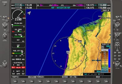
Departing runway 30 at Shelter Cove with a climbing left turn to heading 180 looks to be the way to go since there is quickly rising terrain to the north and to the east. The bad news is that the left turn takes you out over the Pacific Ocean, so it helps to have plenty of confidence in your aircraft. Here's what a G1000 would display on the ground at Shelter Cove.
If you're flying a G1000-equipped aircraft, now is the time to have the terrain feature enabled on the moving map. Whenever you see red on the terrain display, there is terrain less than 100' from your current altitude. Yellow means terra firma is between 100' and 1000' of your altitude. The absence of any colors (or black, if you have the topographic data turned off) means you're more than 1000' above terrain. If you have a hand-held GPS that displays terrain data, don't use it for primary navigation but by all means use it to enhance your situational awareness. Here is the PFD with the inset map in the lower left side of the screen set to show terrain data.
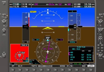
Here's what the PFD might look like climbing out from runway 30 at Shelter Cove.
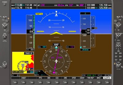
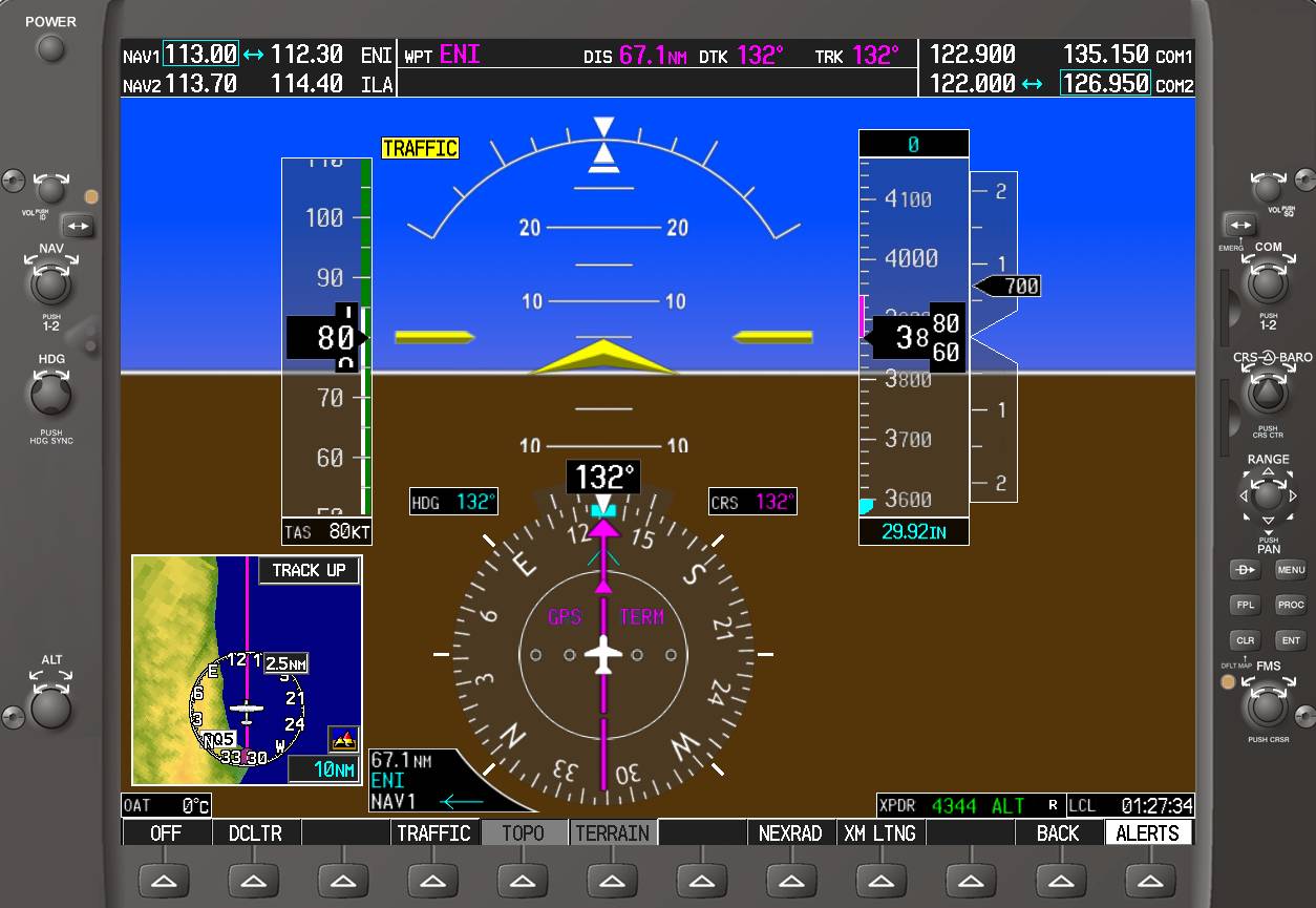
As you begin the left turn toward the Mendocino VOR and begin to gain altitude, you'll begin to see more yellow than red on the terrain display.
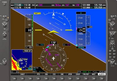
Intercepting the direct course to the VOR, almost all of the yellow and red have disappeared.

If you plan to depart VFR and pick up your clearance airborne, the weather conditions should allow you to climb to a sufficient altitude to establish radio communications with the ATC facility that provides departure control for the area. The last thing you want is to get airborne in deteriorating weather only to find you can't raise ATC on the radio or that ATC can't identify you on radar to issue your clearance. Due to terrain and the remote nature of the location, Oakland Center has limited radio and radar coverage in this area, so your best bet would be to call Flight Service on the phone to get your IFR clearance while still on the ground at Shelter Cove. Last time I was at Shelter Cove (about a year ago), my cell phone couldn't get a signal, but there is a pay phone nearby. You can see why they call this area The Lost Coast.
Departing an airport in uncontrolled airspace (Class G in the U.S.) and for which there is no defined procedure, the pilot needs to do thorough planning. Let's say you're departing Shelter Cove, California for an IFR flight to San Jose. The IFR clearance you receive might sound something like this:
Bonanza 12345 is cleared to San Jose Mineta Airport via, when entering controlled airspace, direct Mendocino, Victor 27, Point Reyes One arrival ...There are no instrument procedures defined for Shelter Cove, so use the appropriate VFR sectional and IFR low altitude en route charts, your knowledge of the local terrain, your aircraft's climb performance data, and some common sense to devise a strategy to climb to a safe altitude for vectors to Mendocino.

The Maximum Elevation Figure on the VFR sectional for the area where Shelter Cover is located is 4,400 feet. The Minimum Off-Route Obstruction Clearance Altitudes on the IFR low altitude en route chart sector for Shelter Cove is 6,400' with a MORCA of 5,000' for the sector to the south, and 9,800' to the East. The Minimum En route Altitude for V27 is 6,700'. The airspace surrounding Shelter Cove is Class G (uncontrolled) from the surface to 1200' AGL, with Class E (controlled airspace) beginning at 1200'. Should the ceiling at Shelter Cove be below 1200', keep in mind that after takeoff you will be operating in instrument conditions in Class G (uncontrolled) airspace until you climb to 1200' .
Departing runway 30 at Shelter Cove with a climbing left turn to heading 180 looks to be the way to go since there is quickly rising terrain to the north and to the east. The bad news is that the left turn takes you out over the Pacific Ocean, so it helps to have plenty of confidence in your aircraft. Here's what a G1000 would display on the ground at Shelter Cove.
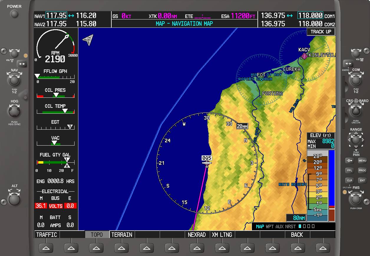
If you're flying a G1000-equipped aircraft, now is the time to have the terrain feature enabled on the moving map. Whenever you see red on the terrain display, there is terrain less than 100' from your current altitude. Yellow means terra firma is between 100' and 1000' of your altitude. The absence of any colors (or black, if you have the topographic data turned off) means you're more than 1000' above terrain. If you have a hand-held GPS that displays terrain data, don't use it for primary navigation but by all means use it to enhance your situational awareness. Here is the PFD with the inset map in the lower left side of the screen set to show terrain data.
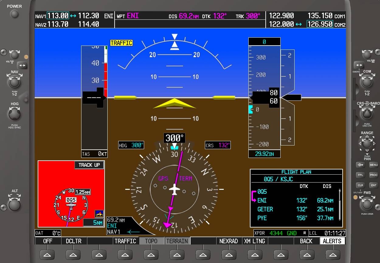
Here's what the PFD might look like climbing out from runway 30 at Shelter Cove.

As you begin the left turn toward the Mendocino VOR and begin to gain altitude, you'll begin to see more yellow than red on the terrain display.

Intercepting the direct course to the VOR, almost all of the yellow and red have disappeared.
If you plan to depart VFR and pick up your clearance airborne, the weather conditions should allow you to climb to a sufficient altitude to establish radio communications with the ATC facility that provides departure control for the area. The last thing you want is to get airborne in deteriorating weather only to find you can't raise ATC on the radio or that ATC can't identify you on radar to issue your clearance. Due to terrain and the remote nature of the location, Oakland Center has limited radio and radar coverage in this area, so your best bet would be to call Flight Service on the phone to get your IFR clearance while still on the ground at Shelter Cove. Last time I was at Shelter Cove (about a year ago), my cell phone couldn't get a signal, but there is a pay phone nearby. You can see why they call this area The Lost Coast.
Saturday, June 17, 2006
What Color is Your Parachute?
Saturday. Beautiful, warm, VFR weather. Father's Day. This is just the combination to strike fear into the heart of a flight instructor. Why? Because everyone and their dog will be flying and with an instrument student under the hood, the only thing between you and a mid-air or near miss is your two eyes. So what's a flight instructor to do? Go flying, keep your eyes peeled, hope you get to fly a plane with TIS (Traffic Information Service), and that you'll be flying in an area where TIS is provided. The other thing I did today was to suggest to my student that we practice holding pattern entries at a fairly high altitude over an out-of-the-way VOR near the coastline.
The holding went well and we were also lucky enough to get traffic advisories from Oakland Center. In fact, the controller seemed to be in a particularly friendly and helpful mood, in spite of the number of aircraft requesting services. I told him that we were finished holding and wanted to go to Petaluma. He told us to squawk VFR and frequency change was approved, then added that there were numerous targets heading into and out of Petaluma and to use caution. And he was right.
Petaluma is a non-towered airport - there is no control tower. Some pilots refer to this as an "uncontrolled field," a misnomer that belies a basic misunderstanding of a pilot's rights and responsibilities. There is control at non-towered airport - each pilot using the airport is to adhere to the procedures described in AC90-66A Recommended Standards Traffic Patterns for Aeronautical Operations at Airports without Operating Control Towers and the recommendations in the Aeronautical Information Manual. While there's no air traffic controller telling people what to do at these airports, each pilot is supposed to use self control and follow the rules. Here are some highlights from these two sources.
Combine these conventions with basic right-of-way rules, plus a dash of common sense and operations at a non-towered field should remain under control. Alas, this is not always the case. Just as in the world of automobile driving, the flying world has its share of pilots who don't know or don't remember the rules, or they simply don't want to bother to follow them.
In addition to the usual confusion caused by a lot of air traffic, today several pilots at Petaluma were using an unapproved radio technique I find ineffective, confusing, and just stupid. Instead of just identifying themselves with their aircraft's manufacturer or type and the last 3 characters/digits of their tail number, like "Piper 33 Xray," virtually all of the aircraft were saying things like "Blue on White Warrior."
Hello? Virtually all GA aircraft are some color or another on white. In fact there were so many "blue on white" aircraft self-announcing their positions today, that everyone was getting confused. Several pilots were referring to their position using local landmarks that out-of-towners were unlikely to know - another unapproved radio technique. And the reason there was so much traffic? There was some sort of fly-in, though I never found out what it was.
As we approached, I thought about a instigating a subtle parody of these other pilots by identifying us as "crimson on white Tobago," but decided to stick with the textbook procedure. We maneuvered for a 45˚ entry about 3 miles out, managed to get on downwind with little conflict, and someone holding short of the runway asked if we could extend our downwind to allow a couple of departures. "Sure can" was our response because it pays to be polite. But not everyone was polite. One pilot, who sounded old enough to know better, began shouting at other aircraft, then blurted out "Goddamn it!" Nice, very nice. We got some fuel and got out of there fast.
Please, please, don't use the "white Cherokee, turning final" style phraseology at non-towered airports. It's not sanctioned, it's confusing, it dumb, and it's potentially dangerous. Use the last three digits/characters of your tail number preceded by your aircraft model or manufacturer and include your altitude with your location, just like you would when talking to ATC. And if you have a chance to do something courteous or help someone out at a non-towered airport, why not do so? Set a good example. We have enough bad examples out there.
Heading out of Oakland today and then heading back in, I saw something that I've seen several times in the last two weeks in TIS-equipped aircraft: An aircraft target with no altitude reported, just north of the Mormon Temple (about 6nm from the Oakland VORTAC on the 355 radial). A few days ago, the TIS in a plane I was flying barked out "Traffic! Traffic!" as we passed. I was looking high and low, but saw nothing.
Today, I got the urge to ask the Oakland Tower controller if he was painting a target in that location with no altitude tag. He kindly explained that this was some sort of phony datum target used by Norcal to calibrate their radar. I thanked him and mentioned that it makes TIS give traffic alerts, but he assured me it was not for real. I wonder, does Norcal have any idea what a pain in the fundament this phony target is for pilots of TIS-equipped aircraft? At the very least, they should inform us that it's there.
The holding went well and we were also lucky enough to get traffic advisories from Oakland Center. In fact, the controller seemed to be in a particularly friendly and helpful mood, in spite of the number of aircraft requesting services. I told him that we were finished holding and wanted to go to Petaluma. He told us to squawk VFR and frequency change was approved, then added that there were numerous targets heading into and out of Petaluma and to use caution. And he was right.
Petaluma is a non-towered airport - there is no control tower. Some pilots refer to this as an "uncontrolled field," a misnomer that belies a basic misunderstanding of a pilot's rights and responsibilities. There is control at non-towered airport - each pilot using the airport is to adhere to the procedures described in AC90-66A Recommended Standards Traffic Patterns for Aeronautical Operations at Airports without Operating Control Towers and the recommendations in the Aeronautical Information Manual. While there's no air traffic controller telling people what to do at these airports, each pilot is supposed to use self control and follow the rules. Here are some highlights from these two sources.
Turn on landing and anti-collision lights to make your aircraft easier to see.
If your aircraft has a radio, self-announce your position and intentions over the Common Traffic Advisory Frequency (CTAF) on Unicom.
Remember that not all aircraft have radios at non-towered fields so be vigilant for traffic and adhere to basic right-of-way rules. Use caution for possible ultralight, glider, balloon, and parachute operations.
While straight-in approaches are not prohibited, it is preferable to do a 45˚ entry to the midpoint on the downwind leg.
Piston aircraft should use 1000' AGL traffic pattern altitudes, turbine aircraft should use 1500' AGL, or the altitudes specified for the airport in the Airport/Facilities Directory.
Report 10 miles from the airport, giving your aircraft type, the last three digits/characters of your tail number, positions relative to the airport, altitude, and intentions. Give similar reports at 5 miles out, entering downwind, turning base, turning final, and exiting the runway.
Fly a standard traffic pattern or the traffic pattern established for the airport (found in the Airport/Facility Directory).
Combine these conventions with basic right-of-way rules, plus a dash of common sense and operations at a non-towered field should remain under control. Alas, this is not always the case. Just as in the world of automobile driving, the flying world has its share of pilots who don't know or don't remember the rules, or they simply don't want to bother to follow them.
In addition to the usual confusion caused by a lot of air traffic, today several pilots at Petaluma were using an unapproved radio technique I find ineffective, confusing, and just stupid. Instead of just identifying themselves with their aircraft's manufacturer or type and the last 3 characters/digits of their tail number, like "Piper 33 Xray," virtually all of the aircraft were saying things like "Blue on White Warrior."
Hello? Virtually all GA aircraft are some color or another on white. In fact there were so many "blue on white" aircraft self-announcing their positions today, that everyone was getting confused. Several pilots were referring to their position using local landmarks that out-of-towners were unlikely to know - another unapproved radio technique. And the reason there was so much traffic? There was some sort of fly-in, though I never found out what it was.
As we approached, I thought about a instigating a subtle parody of these other pilots by identifying us as "crimson on white Tobago," but decided to stick with the textbook procedure. We maneuvered for a 45˚ entry about 3 miles out, managed to get on downwind with little conflict, and someone holding short of the runway asked if we could extend our downwind to allow a couple of departures. "Sure can" was our response because it pays to be polite. But not everyone was polite. One pilot, who sounded old enough to know better, began shouting at other aircraft, then blurted out "Goddamn it!" Nice, very nice. We got some fuel and got out of there fast.
Please, please, don't use the "white Cherokee, turning final" style phraseology at non-towered airports. It's not sanctioned, it's confusing, it dumb, and it's potentially dangerous. Use the last three digits/characters of your tail number preceded by your aircraft model or manufacturer and include your altitude with your location, just like you would when talking to ATC. And if you have a chance to do something courteous or help someone out at a non-towered airport, why not do so? Set a good example. We have enough bad examples out there.
Heading out of Oakland today and then heading back in, I saw something that I've seen several times in the last two weeks in TIS-equipped aircraft: An aircraft target with no altitude reported, just north of the Mormon Temple (about 6nm from the Oakland VORTAC on the 355 radial). A few days ago, the TIS in a plane I was flying barked out "Traffic! Traffic!" as we passed. I was looking high and low, but saw nothing.
Today, I got the urge to ask the Oakland Tower controller if he was painting a target in that location with no altitude tag. He kindly explained that this was some sort of phony datum target used by Norcal to calibrate their radar. I thanked him and mentioned that it makes TIS give traffic alerts, but he assured me it was not for real. I wonder, does Norcal have any idea what a pain in the fundament this phony target is for pilots of TIS-equipped aircraft? At the very least, they should inform us that it's there.
Subscribe to:
Posts (Atom)


+copy.jpg)


