Showing posts with label missed approach. Show all posts

Monday, January 17, 2011

Foggy Inland, Clear at the Coast

Known for it's microclimates, the San Francisco Bay Area weather is a year-round marvel. In the summertime, with little moisture in the Central Valley, the sun often beats down mercilessly on the earth, that in turn heats the air near the surface, the air expands and rises, resulting in an area of thermal low pressure. The summertime pressure gradients between cool, moist coastal areas and the hot, dry Central Valley can be dramatic: It's not uncommon to see a barometric pressure difference of 0.1" Hg or greater between Oakland and Byron, a mere 29 miles away. With the Santa Cruz and Diablo Mountain ranges acting as low altitude barriers, the strong on-shore pressure gradient draws the famous San Francisco fog Eastward, through the Golden Gate and into the bay and other low lying areas.

Winter in The Valley
In the winter months, the effect can be just the opposite. Surface moisture from heavy rainfall combines with low surface temperatures and light winds to form Tule fog in the Central Valley (this is really just a regional term for radiation fog). Add a high-pressure system like the one currently ensconced over North Central California, and you get a temperature inversion that makes the Tule fog persist for days, even weeks. Winter months can often provide an off-shore surface pressure gradient that is just the opposite of the summer pattern. The result is the Tule fog in the Central Valley can be drawn Westward into the Livermore Valley and even into San Francisco Bay.

One benefit of this winter fog pattern is that instrument pilots can depart under visual flight rules (VFR) from Bay Area airports, fly just a few miles to one of several Central Valley airports, and experience instrument approaches to minima - often less than 1/2 mile visibility with indefinite ceilings of 200 feet or less with calm winds. With widespread low IFR, wise pilots and instructors carefully weighs the risks associated with practicing instrument approaches under these conditions.

Seeing an ocean of Tule fog sitting in the Central Valley, but with warm temperatures and clear blue skies aloft is a great way to teach pilots and non-pilots that this type of fog does not burn off. Tule fog will mix into the upper atmosphere and dissipate once the surface winds increase. I still cringe when I hear pilots and weather forecasters (folks who should know better) talk about radiation fog burning off. D'oh!

Here are some recent photographs of Tule fog from above. Having grown up in the Midwest, I'll take Tule fog over sub-zero temperatures and snow shovels, thank you very much.

East of Lake Berryessa

Widespread Low IFR

Tule Fog pilled up behind the Devil's Mountain

Procedure Turn Inbound at KEDU.

Ripples near Rio Vista
There's an airport down there ... somewhere


Monday, October 11, 2010

How Many Engineers Does it Take?

OAK 09/200 OAK NAV VORTAC OTS TIL 1010312359

The Oakland VORTAC has been out of service for, well ... I think it was NOTAMed back in April or May of 2010. Pretty amazing when you consider this is one of the major navigation aids on the West Coast: It defines six Victor airways, six Jet airways, and numerous airports have instrument approaches, departure procedures, and arrivals that rely on it. So what is the FAA doing to the Oakland VORTAC and why is it taking so long? This isn't the entire story, just some of the pieces.

The Oakland VORTAC was missing in action for an extended period about six years ago when a range of radials had become unusable and an effort was undertaken to figure out why. Around that time the Ron Cowan Parkway had just been completed, named after the developer of the nearby Harbor Bay business and residential developments.

Sometimes called the road to nowhere, the project to build the Cowan Parkway figured in an FBI probe that started after allegations of impropriety between Mr. Cowan and then state senator Don Perata. It seems that some folk thought the road was primarily designed to increase the value of Mr. Cowan's real estate holdings at Harbor Bay at taxpayer expense, but that's a deep topic. So moving on I'll point out that the Cowan Parkway divides the Oakland Airport in half, provides alternate access to the FedEx ramp and the South Field terminal as well as an alternate route for residents of Bay Farm Island. Cyclists also benefit from bike lanes that flank the road.

Building the parkway was a big project, in part because a tunnel had to be constructed under Taxiway Bravo, the only connection for taxiing aircraft between Oakland's South Field and the North Field. In addition, airport perimeter barriers had to be adapted and new chain link fencing and razor wire installed. After investigating, it was determined that the new fences were close enough to the VORTAC that they were distorting the signals. Sections of the fencing were replaced with redwood (which you can see in the photo above), the FAA's flight check aircraft conducted various tests, there were still some radials in the Northwest quadrant deemed unusable, but the VORTAC was returned to service and life got back to normal, mostly.


Recently an initiative was undertaken to dopplerize the Oakland VORTAC to increase its accuracy and eliminate or reduce the number of unusable radials. This is the project that started in earnest last spring and after a month or so, a bunch of little mushroom-shaped antennae were seen ringing the main bowling pin antenna.

In July the flight check aircraft was testing the results. I remember one of the days because the FAA's flight check King Air made quite a stir, flying the OAK VOR RWY 9R approach when all other traffic was landing runways 29, 27 Left and 27 Right. A student I was flying with had to break off a practice approach, but I didn't mind because I assumed this meant progress was being made. Yet as the end of July approached, the NOTAM was changed to show the VORTAC returning to service at the end of September. Then I got wind of some of what was going on.

It seems that the new configuration failed the high-altitude flight check and a new effort was underway to determine why. At one point a theory was that surplus concrete debris that the airport facilities folks use to repair the numerous dikes and levees around the airport was causing the problem. The concrete chunks were piled up near the VORTAC, some of the chunks contained rebar, and the thought was this was distorting the VORTAC's signals. This isn't the first time rebar has affected aviation at Oakland: A few years ago it was discovered that both compass roses had been constructed with concrete that contained rebar, which could explain why so many compasses that were swung at Oakland seemed screwed up. The compass roses remain closed.

USD 05/081 NUQ AIRSPACE SOUTHLAND ONE DEPARTURE... NA EXCEPT FOR AIRCRAFT EQUIPPED WITH SUITABLE RNAV SYSTEM WITH GPS. OAK VORTAC OTS.

USD 05/083 LVK AIRSPACE LIVERMORE ONE DEPARTURE... PROCEDURE NA EXCEPT FOR AIRCRAFT EQUIPPED WITH SUITABLE RNAV SYSTEM WITH GPS. OAK VORTAC OTS.

USD 05/085 SFO AIRSPACE PORTE THREE DEPARTURE TAKE-OFF RUNWAYS 10L/R AND 19L/R: PROCEDURE NA EXCEPT FOR AIRCRAFT EQUIPPED WITH SUITABLE RNAV SYSTEM WITH GPS. OAK VOR OTS. 

USD 05/097 SFO AIRSPACE SHORELINE ONE DEPARTURE...
PROCEDURE NA EXCEPT FOR AIRCRAFT EQUIPPED WITH SUITABLE RNAV SYSTEM WITH GPS. OAK VORTAC OTS. 

USD 05/082 OAK AIRSPACE SKYLINE THREE DEPARTURE...
RWYS 9L, 9R, 11 NA EXCEPT FOR AIRCRAFT EQUIPPED WITH SUITABLE RNAV SYSTEM WITH GPS. OAK VORTAC OTS.

USD 05/084 OAK AIRSPACE MARINA FOUR DEPARTURE...
NA EXCEPT FOR AIRCRAFT EQUIPPED WITH SUITABLE RNAV
SYSTEM WITH GPS. OAK VORTAC OTS. 

USD 05/149 OAK AIRSPACE SALAD ONE DEPARTURE NA EXCEPT FOR AIRCRAFT EQUIPPED WITH SUITABLE RNAV SYSTEM WITH GPS. OAK VORTAC OTS.

USD 05/087 CCR AIRSPACE BUCHANAN NINE DEPARTURE PITTS TRANSITIONS: NA EXCEPT FOR AIRCRAFT EQUIPPED WITH SUITABLE RNAV SYSTEM WITH GPS. OAK VORTAC OTS.

USD 05/086 APC AIRSPACE LIZRD THREE DEPARTURE OAKLAND TRANSITIONS: NA EXCEPT FOR AIRCRAFT EQUIPPED WITH SUITABLE RNAV SYSTEM WITH GPS. OAK VORTAC OTS.

Another repercussion has been that a local freight carrier cannot use the SALAD ONE departure because many (or all?) of their aircraft are not RNAV equipped. So instead of departing runway 27L or 27R, turning East over the San Leandro Bay, and intercepting the 060˚ radial, they have to fly heading 310 until high enough to be vectored to the East. The 310 heading takes them right over residential areas of Alameda late at night and in the early morning hours.

Pilots who wish to fly the HWD LOC/DME RWY 28L approach are required to be flying aircraft equipped with a suitable RNAV system because the missed approach holding fix is (wait for it) ... the Oakland VORTAC. I got bitten by this one a couple of weeks ago when the weather into Hayward didn't clear as forecast. My student had to fly the ILS into Oakland, then we sat and waited for VFR weather so we could reposition back to nearby Hayward. Live and learn.

VORTAC with new Counterpoise
I don't know if the theory about rebar in scrap concrete interfering with the VORTAC was itself scrapped, but the latest development was an assessment that the counterpoise (the roof of the VORTAC building) was too small. An effort was undertaken to enlarge the roof, increasing its diameter by some 16 feet to a total diameter of 84 feet. It looks like this part of the project is mostly completed and the latest NOTAM claims the OAK VORTAC should be back in service by the end of October, 2010.

In 2002, the man for whom the road was named defaulted on over $43 million in loans from Lehman Brothers and the investment bank and its property management company seized much of what Cowan owned at Harbor Bay Business Park. The road itself is not heavily travelled, though it did end up reportedly costing taxpayers over $100 million. The road appears indirectly responsible for trouble faced by pilots and a noise-sensitive community. The weather is bound to get worse as winter approaches and fixing the Oakland VORTAC could go down to the wire. We'll just have to wait and see if the FAA can pull a rabbit out of their hat or if the Cowan Parkway will continue to be the gift that keeps giving.

Wednesday, March 17, 2010

Something Can Be Done

The promise of Area Navigation (RNAV and GPS) was that it would be a simpler and more accurate way to navigate than older styles of navigation and to a great extent, that promise has been realized. GPS accuracy, especially when augmented with WAAS, is very good indeed. As for simplicity ... not so much. Waypoint navigation was a revolutionary concept when it was introduced, but it has been integrated with existing navigational paradigms and infrastructure in an evolutionary manner, not unlike the way an artist might sculpt clay or mold papier-mâché. This evolutionary approach has created some unfortunate and unforeseen complexity, but it doesn't need to be that way. Mom always said "Don't complain unless you can offer a solution or a suggestion," so here are my top five recommendations for simplifying the world of RNAV.

Wayward Waypoints


Many airports out there have a VOR located at airport and in those cases the VOR and the airport have the same name. Just as often the VOR may be some miles away from the airport, but both still have the same name. At the heart of every GPS receiver is a computer running software and software doesn't tend to handle ambiguity very well. That's why the GPS database encodes airports using a four-character ICAO identifier and VORs with a three-character identifier. The FAA's charting division could do us a big favor by using four-character ICAO airport identifiers on their chart products, but they don't. If they did, it would be crystal clear to student pilots and budding instrument pilots that KSAC refers to the surveyed center of the Sacramento Executive airport while SAC refers to the Sacramento VOR. 


Not in Kansas Anymore

The first step in GPS navigation is to enter the name of a VOR or NDB station on the ground, the name of an intersection of two VOR radials, an airport ID (which represents the surveyed center of the airport), a charted VFR reporting point, a Computer Navigation Fix defined by FAA chart designers, or even a user waypoint that you've created. The AIM refers to this type of navigation as to-to, not to be confused with Toto, the little black terrier in the Wizard of Oz. GPS receivers only navigate to one waypoint at a time, also known as the current waypoint.

GPS makes it simple to navigate to a waypoint and most receivers provide a moving map display, which is a score for simplicity and safety. The bad news is that unless you're lucky enough to have a keyboard as part of your GPS receiver, entering a waypoint requires a precise and often convoluted sequence of knob-turning and button-pushing. A bad user interface makes it all too easy to misspell the name of the waypoint: Get just one letter wrong and instead of navigating to a VOR that is 20 miles away, you may be headed to Tierra del Fuego by mistake!

The engineers that designed GPS receiver user interfaces didn't set out to create difficult-to-use products, but the fact is they did. Whether it was the desire to save a few bucks by having fewer knobs and buttons or simply a race to get a product to market, it's clear that mistakes were made. Now the users of these products have to live with the mistakes and to quote Warren Zevon, "… it ain't that pretty at all." Bad UI design is the Achilles heel of GPS and many of us pilots have become so acclimated to these convoluted interfaces that we have lost sight of just how whacked this situation is.

Near the top of my "need to fix" list is Garmin's Small-Knob/Big-Knob interface. You press the small knob to enter "cursor mode" so you can edit or enter the name of a waypoint in a flight plan. You turn the small knob to start the process of entering letters and then the small knob changes function. Whoa there! A knob whose function changes depending on an interface context that is mostly invisible to the user? This needs to be fixed and one simple way would be a separate button dedicated to starting and ending the waypoint editing mode.

Having a separate button for edit mode would also fix the problem that countless new Garmin users run into: Pressing the small knob to exit cursor mode and accept whatever changes they have made. Having watched hundreds of pilots make this mistake thousands of times it's clear that a common intuitive belief is that if you press one button or key to enter a mode, pressing the same button or key should exit that mode. In the Garmin world, this simply exits the editing mode and, here's the amazing part, destroys whatever changes you made without asking you to confirm that's what you want to do. This is B-A-D.

Missing Pieces on the Missed Approach

When flying an instrument approach, most GPS receiver are designed to suspend the automatic sequencing of waypoints when you reach the missed approach point. Think about this for a moment: You're close to the ground with reduced obstruction clearance at a high-workload moment. You're either going to see the runway and land or you won't see anything and you'll fly the missed approach. Is this really the time to make a pilot divert their attention from controlling the aircraft to push the OBS button or SUSP soft-key? I don't think so and apparently neither did the designers of the GNS 480 (nee CNX 80), which will automatically sequence to the missed approach segment. If you see the runway environment and decide to land, you just ignore the GPS. If you don't see the runway environment or loose sight of the runway while circling, use the GPS to start navigating on the missed approach. Too bad the GNS 480 is out of production and the GPS units that are in production don't exhibit this behavior. A defense I've often heard is that the TSO specifies that pilot action is required to initiate the missed approach and if this is true, the TSO should be changed.

When flying a non-RNAV approach, many GPS receivers automatically switch the navigation source from GPS to the VOR or localizer receiver. That's great, but if you need to fly the missed approach and you want to use the GPS to do so you must divert your attention and manually select GPS as the navigation source. I mean really! If it's okay to automatically switch navigation source out of GPS, why not back into GPS mode?

Four Card Minima

There's a new game for RNAV approaches that all pilots must play and it's called "Guess the approach minima." It goes something like this. When you brief an RNAV approach, you may see up to four sets of minima listed: LNAV, LNAV/VNAV, LPV and circling. The issue is you may not know which minima your WAAS GPS receiver can offer (based on current signal integrity) until a few miles before the final approach fix. This has to do with the design of WAAS GPS receivers' final signal integrity check and I honestly can't think of a good way around this shortcoming: You just have to brief multiple approach minima and choose the correct minima based on the approach sensitivity your WAAS GPS receiver displays.

Where improvement could be made would be to ensure that the approach sensitivity displayed on the GPS receiver exactly corresponds to the approach minima shown on the chart. If your receiver arms with  LPV or LP sensitivity, you're okay because your WAAS GPS receiver should display LPV or LP. If the receiver arms with LNAV sensitivity, you may see LNAV or LNAV+V. If it arms with LNAV/VNAV you'll probably see LNAV/V. Notice the subtle, similar appearance of LNAV+V and L/VNAV? This is too subtle and is B-A-D. And the minima shown on the charts should exactly match the minima displayed on the GPS receiver, period, end of discussion.

Procedure Turn or No?

The introduction of the Terminal Arrival Area (or TAA) was meant to simplify pilot/controller interaction when executing an RNAV approach. And it would be simpler, were in not for the fact that not all RNAV approach charts follow the same conventions with regard to the depiction of a hold-in-lieu-of procedure turn (or HILO). In particular, some RNAV approaches have a standard Minimum Safe Altitude circle while others display minimum safe altitudes in sectors on the plan view of the chart. The subtle problem is that MSA sectors will usually tell the pilot that the procedure turn is not authorized when you're headed straight-in to an Initial Approach Fix where a HILO is depicted, while approaches with the MSA circle do not.


If you were approaching from the Southeast and were told "when able, proceed direct HERMIT, cleared RNAV 34 approach" you need to read the fine print on the MSA sector shown on the plan view to know when you could descend and to know that the HILO is not authorized.


If you were told "when able proceed direct CADAB, cleared RNAV 29 approach," you need to know that the hold-in-lieu-of procedure turn is required unless the the controller remembers to say "… cleared straight-in RNAV 29 approach."

The FAA charting division needs to come up with a consistent way of depicting MSA and clearly denoting when a procedure turn is required and when it isn't. Until then, pilots should ask the controller when they see a HILO and they aren't sure whether or not they are expected to fly the procedure turn.

More Fond Wishes

So that's my wish list of the top five features and enhancements I'd like to see for the world of RNAV. You may have your own list of desired features, too. For now, we can only hope that the people in a position to fix these issues are listening.

Saturday, November 21, 2009

Surprise, Surprise

The concept of automation surprise has been around for years in the large aircraft world and now it's part of the GA aircraft that you are flying or might soon be flying. Automation surprise occurs when a system, such as a GPS receiver and/or autopilot, does something the pilot neither expected nor intended. The result is that the aircraft deviates from an assigned heading, route, altitude, or approach path and the pilot may lose situation awareness, too. Actually, it's the pilot-in-command who is considered to have deviated, not the plane or it's systems and blaming the machine is an argument that's probably not going to hold water. With all the technically-advanced GA aircraft out there, automation surprise is now something that GA pilots must understand and be ready to handle.

While I don't pretend to be a human factors expert, I've both witnessed and been on the receiving end of automation surprise on several occasions. Most of the surprises I've seen in GA aircraft resulted from the pilot making mode errors - not fully understanding the consequences of their knob twisting and button pushing. Yet I have also seen deviations result from equipment failures and even from shortcomings in the design of an instrument procedure. There can be a seemingly endless number of ways for things to go wrong in a complex, automated environment and while we may want to never make any errors, mistakes are going to happen. I'll provide just a few examples of how things can get out of hand when technology is busy making the pilot's job easier and what you can do when the magic turns evil.

Operator Error
Here's a mistake I've witnessed many pilots make with the two-axis KAP-140. ATC instructs "... climb and maintain 7000." You decide it's time for George to do some flying. So you press and hold AP for 1.5 seconds, then press HDG, then select 7000 feet, then press ALT, and are subsequently confused as to why the KAP-140 won't allow you to use the UP button to select a vertical climb rate.


The key is understanding that the KAP-140 goes into VS (vertical speed) mode by default when your press the AP button. The mistake was pressing ALT, which engages altitude hold mode irrespective of the altitude you just dialed in - an odd design, to say the least! Pressing ALT a second time restores VS mode and allows you to enter a vertical climb rate. The problem is that the second time you press ALT to enter vertical speed mode, the altitude you selected is not armed. That means you'll climb, but the KAP-140 will not capture the selected altitude and if you're not paying attention, you'll bust your clearance. Blast!

Having your own SOP (Standard Operating Procedure) for autopilot use, combined with actually looking at the modes being displayed, can help circumvent this problem. A better knobology sequence would be: Dial in 7000 feet, pitch up for the desired climb rate, press and hold AP for 1.5 seconds, then press HDG, then press ARM. This results in the following KAP-140 display: HDG [AP] VS 7000 ALT Armed. The KAP-140 will climb at 500 feet per minute, fly the bugged heading, and level off at 7000 feet.

Unexpected Mode Changes
In an effort to make the pilot's job easier, Garmin's G1000 will automatically switch the navigation source from GPS to a localizer on an ILS, LOC or LDA approach. Interestingly, the G1000 won't automatically switch back to GPS for the missed approach procedure - you must manually switch the navigation source back to GPS. While this may sound like a good feature, it actually creates unintended consequences in aircraft equipped with a Bendix/King KAP-140 autopilot. Here's the setup.


You're flying the Concord LDA RWY 19R approach, approaching from the South, you've requested pilot navigation, Travis Approach has approved, and you're cleared to "cross KANAN at or above 4000' cleared LDA 19 right approach." You've selected and activated the approach on the G1000 with KANAN as the IAF. Your KAP-140 autopilot is engaged in NAV and ALT modes and it is flawlessly tracking a direct course to KANAN.

Crossing KANAN, the GPS sequences to fly the procedure turn and the KAP-140 continues to do a great job. You select 2500 feet, press ALT to enter VS mode, press DN a few times to command a 400'/min descent, and remove some power to keep the airspeed under control. The GPS and the KAP-140 turn the airplane to the outbound procedure turn, then after a minute, they turn the airplane inbound to intercept the approach course.

Reaching 2500 feet, you restore some power and the G1000 then automatically switches the navigation source to the localizer. If you're not observant, you will miss this mode change. The HSI needle changes color from magenta (for GPS) to green (for the localizer) and the switch in navigation source causes the KAP-140 to silently enter ROL mode. That's right, there's no aural alarm to alert you that this mode change has happened, just ROL flashing on the KAP-140 display - which is out of your primary field of view. If you don't realize the KAP-140 is in ROL mode, the airplane will fly right through the localizer. Ooops!

One SOP you could use to prevent this is to always change the KAP-140 to HDG, manually change the navigation source to the localizer, and follow the GPS prompts to manually command the procedure turn using the heading bug. Once you've turned inbound to intercept the localizer, press NAV and the KAP-140 will capture the localizer course.

Missing the Missed Approach
The Garmin G1000, as well as the 430/530 GPS receivers, can help you fly the missed approach using GPS navigation as long as everything goes as planned. For an ILS approach, the GPS must handle two possible cases: The full ILS and a localizer-only approach. The GPS considers the MAP to be at the runway threshold, even though the MAP on an ILS is technically at decision height, on glide slope, and on the localizer course.

For these GPS receivers to suspend waypoint sequencing, you need to fly over the MAP at the runway threshold. Only then can you press the OBS key (or softkey) to re-enable waypoint sequencing, switch the navigation source back to GPS, and fly the missed approach using the GPS. If you don't fly over the MAP, waypoint sequencing won't be suspended and you'll need to do some more work to activate the missed approach. If you don't understand this GPS behavior, you could find yourself very confused at a high workload moment. Do'h!

Procedure Problems
Though rare, automation surprise may occur due to the way an instrument procedure was designed. This is exactly what happened to a pilot I was flying with recently on an approach I had flown many, many times before. The thing is, it had been quite a while since I flew this approach and the procedure had changed. Here's what happened.

The pilot requested the Sacramento Executive ILS RWY 2 practice approach with the published missed approach. Approach responded "... cross COUPS at or above 3000, cleared ILS 2 practice approach." The pilot selected the approach and activated it with COUPS as the initial approach fix. The autopilot was engaged in NAV mode and flew us to COUPS. What happened next was both dramatic and unexpected.


Reaching COUPS, the GPS commanded a 41 degree heading change to the left from a 015 track to a 334 track to navigate to the newly added Computer Navigation Fix (CNF) UBIYI: A 41 degree heading change for a leg that is only 0.2 miles long! The groundspeed was only 110 knots, but there was no time for GPS turn anticipation to smooth this out. As soon as the GPS commanded a turn to the left, it commanded a turn back to the right as the airplane blew through the approach course. It happened so fast that we both wondered what was wrong. Was this a GPS error or an autopilot error?

No sooner had we begun to doubt the automation, the plane was headed back to intercept the localizer. You have to look really closely at the chart to see that the GPS and the KAP-140 were just trying to fly the approach as it is coded. I emailed the FAA to suggest they take another look at the unintended consequences of the change that was made. Good idea!

Ounce of Prevention
The primary ways a pilot can prevent automation surprise are both simple and straightforward:
  • Know your own limits with regard to currency/proficiency
  • Know thy aircraft's equipment
  • Monitor what the automated systems are doing
  • Stay ahead of (or at least be in synch with) ATC's game plan
  • Maintain situational awareness
  • Develop and use SOPs (standard operating procedures)
  • And be prepared to catch and correct errors.

I'd like to be able to tell you that the average pilot can fly a G1000-equipped aircraft once a month and maintain instrument proficiency. Sadly, this is usually not the case. Unless you are practicing regularly with a G1000 PC Trainer or other simulator, you'll get rusty - fast! Part of this erosion of skill is due to the vast number of features the G1000 offers, but much of the problem lies in the user interface's annoying design that requires you to recognize subtle changes in operational modes. I don't want to mince words here: The G1000 and other GA GPS receivers are not easy to use. They require regular use and practice for pilots to maintain proficiency.

PC-based simulators can be an effective and inexpensive way to maintain your instrument chops, but you need to have a plan. Sitting down and just screwing around is not going to serve you well. As they say in the music world: "If you play when you practice, you'll practice when you play."

A suggestion I've made before is to treat your autopilot and GPS like you would a low-time private pilot. It's okay to trust the systems, but monitor them to ensure they are doing what you intended. This is particularly important during transitions to climbs, descents, level-offs, turns to a heading, and intercepting and tracking a navigational course. So periodically interrupt whatever you were doing to ensure George is still flying the plane the way you intended. Did it capture the altitude you programmed? Has it intercepted the navigational course you intended? Is the autopilot still operating in the mode(s) you intended? If not, promptly drop what you are doing, intervene, fly the plane, and then try to determine why or George will trim you into a stall, flying you into the ground, or take you off course.

Remember that you are the last line of defense when automation goes bad. Never, ever forget that fact.

Tuesday, November 28, 2006

If it's Baroque, Part III

Time is a valuable commodity, especially when you are hand-flying an aircraft by reference to instruments. You need to have good aircraft control to hand-fly in the goo or you won't have time to attend to other flying chores. Staying ahead of the game is the name of the game while flying on instruments, yet I often give instruction to pilots so fixated on precisely holding a heading or altitude that they squander plenty of opportunities to finish other important IFR tasks. To manage a precious commodity like time, you need to set priorities or you'll fall into the hole.

Pilots who like to get a jump on things, who like to optimize, who seek precision, maybe even perfection, usually make good instrument pilots because single-pilot IFR in a small aircraft is like riding a mountain bike while simultaneously playing chess. That's why the really good instrument pilots find a way to reconcile their perfect, ideal vision of precise flying with the harsh realities of the turbulence, weather, icing, and equipment failures. While striving to fly precisely and smoothly, instrument pilots need to remember that VOR courses are rough, DME units quit working, GPS receivers give RAIM failures, and ATC often finds the worst possible moment to give you an amended clearance. That's when you find yourself in the hole. Now it's time to cut to the chase, take a bite of your Powdermilk Biscuit™ and do what needs to be done.

To get yourself out of the hole, there are really just four existential questions that you need to be able to answer.

Where am I?

Where am I going?

How will I get there?

Where am I going after that?

In a perfect world, we complete the approach briefing while more than 25 miles away from our destination airport. We already have the ATIS recorded, the altimeter(s) set, the radio frequencies set, the navigational aids' Morse code identifiers verified, and a RAIM prediction completed. But sometimes the real world doesn't cooperate - your plane ices up, you need to divert around some weather, or ATC vectors you all over hell before dumping you on the approach course, too close and too high. When you find yourself behind and getting further and further behind, you need to be able to implement the crisis approach briefing and get yourself out of the hole.

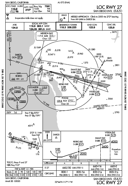
The first step is to quickly digest and configure the minimum navigation setup that will get you to the airport. I find that once a pilot has completed this initial set-up, most are able to relax and complete a more thorough briefing as they get vectored to the approach course. So forget about having three different ways to verify the final approach fix, at least initially. Later you will carve out some time to do a complete briefing at bit at a time (including all three ways to identify the final approach fix). To illustrate the crisis briefing, consider the localizer approach for San Diego's Lindbergh Field.


I flew this approach several times as a freight dog and SoCal approach often wanted to clear me for a visual approach. The first time this happened, I went along with the notion of a visual approach because it would save me time. Then I realized that I was heading into the setting sun and couldn't call the field in sight. The lesson I learned was to make a point of being prepared to fly an instrument approach, even if my destination airport was reporting VFR conditions.

If you checked in with ATC without reporting that you had the current weather for San Diego, the controller should have given you the altimeter setting and asked you to report when you had the current weather. If you lied and told ATC you had the current weather when you didn't, now is the time to tune in the ATIS and at the very least note the wind direction and speed, the ceiling and visibility and the altimeter setting. Not having the current weather at the destination airport and not having the correct approach briefed prior to being handed off to the last approach controller are the hallmarks of a poorly-prepared pilot. Regardless of your concept of your own flying, today you are poorly prepared. You'll have to deal with it and move on if you want to get out of the hole.

San Diego is a big city airport and SoCal is going to give you vectors to the localizer, so this will make your life easier, right? Not necessarily. Frequent heading changes and altitude assignments can be a distraction, actually increasing your workload. So start answering the four existential questions.

Where are you? Somewhere to the east of Lindbergh Field.

Where are you going? To Lindbergh Field, of course!

How will you get there? You're getting vectors to the localizer approach.

Where are you going next? You going to descend on the localizer approach and ultimately see the runway and land or fly the missed approach.

Look at the title of the approach and read it out loud to make sure you have the correct chart. Fly IFR long enough and all approach charts start to look the same. It may sound pedantic to read the name of the approach out loud, but I've seen pilots (including yours truly) do some astoundingly dumb things when under pressure.

Next, glance at the briefing strip. Virtually all NACO approach charts have a briefing strip format similar to Jepp charts. The briefing strip contains the main items that will get you to the runway, namely 1) the localizer and 2) the DME. The briefing strip also tells you the approach course, the touchdown zone elevation, the missed approach procedure, and the important communication frequencies.


Many pilots I fly with insist on struggling with the chart and setting up the frequencies by hand, which is fine if you have an autopilot or another pilot sitting next to you. And if you aren't flying a plane equipped with a later model GPS receiver, this is what you have to do. If you are flying an aircraft with a Garmin 430/530 or a G1000, do yourself a favor - Swallow you pride, press the PROC button and just load the damn approach! Many pilots do this as an afterthought and in the process they create a lot of work for themselves.

In the case of the localizer approach into Lindbergh, loading the approach in a Garmin 430/530 or G1000 will automatically put the localizer in the back-up frequency. All you have to do is swap the localizer frequency in the active slot, identify it (this should be done automatically by a Garmin 530 or G1000), and then set course and source: Set the OBS or HSI (for non-G1000 systems) to the approach course and verify that the navigation source is the localizer and not the GPS. Tune the DME to the same frequency, take a deep breath, relax, and go back to concentrating on flying the vectors and altitudes that ATC is giving you knowing that a big chunk of the approach set-up work is complete.

What about activating the approach in the Garmin GPS, you ask? Simply loading the approach will display the step-down fixes and where you are in relation to those fixes on the moving map, but you'll have to do some fancy knob-twisting and button-pushing to activate the correct leg of the approach. If you think you're back on top of the approach, go ahead.

To get you on an approach course intercept, ATC should give you your position relative to a published fix on the approach, a heading to fly, an altitude to maintain until established, and your approach clearance. Before this happens, you should have plenty of time to digest the rest of the approach.

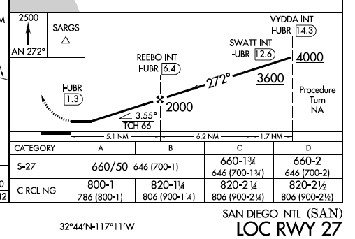
Once you are established on the localizer, keep the localizer needle centered and keep track of your distance from the missed approach point. This is a good time to let your focus shift to the profile view, which lists the fixes and the altitudes to fly as well as the basic missed approach instructions. When you are a about 5 miles from the final approach fix, then press the PROC button and select Activate Vectors to Final if you haven't already activate the approach.

And what about that missed approach procedure, you ask? Note that the missed approach instructions tell you to fly the 272 degree bearing from the AN LMM to a VOR cross radial, which defines SARGS. Funny thing, the chart doesn't say that ADF is required nor does it say you can fly the localizer backcourse to SARGS. It's quite likely the backcourse is unusable, since there is an ILS approach to the opposite runway that uses the same frequency and SARGS is the final approach fix for the ILS. What gives? I wish I knew, but I don't. I've seen other approaches like this and when someone asked the FAA instrument approach procedures folks for an answer, the answer was often that the chart was updated to say "ADF required." If you are not flying with an IFR-certified GPS, you're going to have to work this out. Hopefully you have ADF in your aircraft or perhaps an FMS since you're flying into a busy Class B airport.

If you do need to fly the missed approach with a Garmin 430/530 or G1000 equipped plane, you'll have two important button pushes to make after you have passed the missed approach point and after you have configured the plane to climb (remember to climb and fly the plane first): Press the OBS button to re-enable waypoint sequencing and set the navigation source to the GPS. In non-G1000 aircraft, you'll also have to set the desired track on the OBS or HSI.

Hopefully you will not have to fly the missed approach and you will find yourself safely on the ground, where you will promise yourself that next time you'll be better prepared and that you won't fall into the hole.
Related Posts Plugin for WordPress, Blogger...