Showing posts with label gps efb. Show all posts

Wednesday, March 16, 2011

The iPad 2 Cometh


After some toing and froing with FedEx, I was able to get my grubby hands on the new 16GB Wifi iPad 2 I'd ordered. Here are some first impressions from un-boxing to running a few of my favorite EFB apps.

Unboxing

I decided on the non-3G version and the smaller size, based on my iPad 1 experience. I loaded a bunch of aviation charts and assorted junk (although no music files or videos) on my 32Gb iPad 1 and found that barely used 7Gb of space. And since I have the GNS 5870 MFI Bluetooth GPS Receiver, there was no need for the self-contained GPS in the 3G models. I know some readers have the 3G iPad 1 and like the built-in GPS, but for me the extra $130 for that option wasn't in my budget.

Necessity is the ...


Physically, the iPad 2 is noticeably thinner and lighter. This creates some issues with the currently available kneeboard solutions. I found the iPad 2 is just enough smaller and thinner that it slides around inside the iPro Aviator. I believe it could be made to work with some strategically placed padding, such as foam weatherstripping. Adding a semi-rigid case adds some bulk and helps reduce the looseness, though sadly these don't come with a screen protector like the iPad 1 cases did.

Foam Addition to iPro Aviator Kneeboard

The thinner and smaller size creates the same problems with for the Tietco kneeboard, which is what I tend to use due to it's lighter weight. Again, some creative modifications with weatherstripping and zip-ties seems to create adequate holding power. Again, the semi-ridgid gel case helps reduce the looseness.

Custom Foam Spacer (secured with zip-tie)
While the new screen may not be the retina display everyone was hoping for, it seems a bit brighter than the iPad 1 screen. Or maybe that's because I have a screen protector on my iPad 1 and not on the iPad 2 (they are currently backordered).

Semi-rigid Clear Case
Setting Up

Say what you will about Apple being the new evil empire (and there is evidence this is becoming the case), but the iPad 2 setup was the height of simplicity. I just plugged it into my Macbook, registered the unit with iTunes, and then selected to restore a backup of my iPad 1 contents. In under 4 minutes, everything was complete and ready to rock.

ForeFlight required me to re-download charts, but was noticeably faster than the old iPad: 39 charts took under 8 minutes (I didn't actually time it). Downloading charts into SkyCharts Pro also seemed much faster.

Data for all my other apps appeared as they did on the iPad 1. No muss, no fuss.

Speed Impressions

Everything seems to happen a lot faster on the iPad 2, probably due to twice the amount CPU cache and a faster graphics chipset. A simple example is the auto-screen rotation: Turn the iPad 2 and the screen just snaps into the new orientation instead of the slight delay seen with the iPad 1. Scrolling around in a VFR chart with either ForeFlight or SkyCharts Pro is very, very fast. The real litmus test for me was scrolling through PDF documents in GoodReader. Open a big document like the FAA's Advanced Avionics Handbook and the pages are rendered almost as fast as you can scroll. There's a slight delay rendering pages with lots of graphics, but the overall speed increase is a big step forward.

More to Come

The weather here has not be very conducive to flying, but as soon as I can get airborne I'll post my impressions of the iPad 2 in flight. Stay tuned.

Wednesday, March 9, 2011

ForeFlight Geo-referencing and OpSpec Approval

Don't Use for Navigation


Even if you're an old school pilot who secretly thinks the road to hell is what's displayed on a moving map, I'll still wager that you'll find geo-referenced approach charts and airport diagrams compelling once you see them in action. ForeFlight's new geo-referencing feature is the result of licensing of original technology developed by Seattle Avionics. This option increases the yearly ForeFlight subscription from $74.95 to $149.99, but you can also buy subscriptions for more than one iPad or inquire about a corporate subscription plan. And while a Jeppesen has generated a lot of buzz by announcing OpSpec approval for at least one operator using their iPad app, you should know that the same approval for ForeFlight Mobile HD (FFM) on the iPad has also been accomplished. More on that later.

Required Ingredients

To use ForeFlight's geo-referencing feature, you'll need two ingredients. You'll need to pay the additional fee and you must have some sort of GPS. If the additional fee seems costly, consider this: The annual FFM subscription includes all of the Aeronav charts and procedures one could want for a cost that is only slightly more that what you'd pay for a Jeppesen Mobile TC subscription for California only (sans geo-referencing, by the way). That makes FFM a pretty good value, if you ask me.

The built-in GPS-A found in the 3G iPad may work okay on the ground, then again it may not. In the air, relying on the built-in GPS-A would be a pretty dicey plan. For my testing, I used the GNS 5870 bluetooth GPS which I've been flying with for several weeks now. To date the GNS 5870 has performed flawlessly: It has achieved satellite lock reliably and quickly and the data it provides to ForeFlight Mobile HD has basically matched the GPS data I've seen displayed on panel-mounted GPS receivers like the Garmin G1000, 530W and King KLN 94. I certainly don't sanction relying on a bluetooth GPS for primary navigation, but it's a nice back-up to have on board.

You are ... Here

The geo-referencing in FFM is provide on approach procedures and airport diagrams only. When this feature is available, you'll see a light blue box drawn around the plan view on the approach chart or around the airport diagram. Once you are within the area being covered by the chart, your location will be shown with a little blue airplane surrounded a pulsating animation.


If you want to see your groundspeed, track and other GPS-derived information, you'll need to go into the settings and disable the Auto-Hide Toolbar option. Otherwise, the navigation tab will disappear after a few seconds and you'll have to tap on the center of the chart to get it back. Displaying navigation information during an approach is overkill if you have a panel-mount GPS, but on the taxiway diagrams it provides a good indication if you are taxiing too fast (a bad habit that many pilots have).


There are some accuracy limits to the taxiway diagrams. On a couple of occasions I noticed the airplane's position was being shown slightly off the taxiway we were actually on, but most of the time it was spot on.

On the Main Ramp, but showing "in the dirt"


In the air, I found the accuracy with the GNS 5870 was quite good. In particular, the map gives you a good idea when you're about to intercept an approach while being vectored and helps you maintain situational awareness when flying a full approach with a procedure turn or hold-in-lieu-of-procedure-turn. I even tried it out on a circle-to-land approach: I zoomed in on the approach chart, saw the aircraft's position as being abeam the touchdown zone, and the position was spot on.

Right downwind, abeam RWY 20

One minor gripe is that when you zoom in on a geo-referenced chart, the blue airplane that represents your position is not scaled to match the new chart scale. The result is that the more you zoom in, the smaller the airplane symbol appears.

To Buy or Not to Buy

If you have a panel-mounted GPS and are on a tight budget, you can probably forego the geo-referenced approach chart and taxiway option in FFM. But for not a lot of extra dough, I find this option to be useful enhancement to safety and situational awareness. You'll also need to invest in either a bluetooth GPS like the GNS 5870 MFI Bluetooth GPS Receiver or something like the Bad Elf GPS Receiver.

Getting Approved

Operators who want to get approval to use an iPad solution from their FAA Flight Standards District Office may be interested to know that Cutter Flight Management, Inc. has received authorization to use the iPad with ForeFlight Mobile HD and Jeppesen Mobile TC. Cutter will use ForeFlight to provide domestic en route charts and terminal procedures with Jeppesen providing terminal procedures for international operations. The process for operators gaining OpSpec approval for an EFB is detailed in AC 120-76A, the EFB Job Aid, and in Order 8900.1, volume 4, Chapter 15, Section 1: Electronic Flight Bag Operational Authorization Process.

The EFB evaluation process usually takes about six months with an additional two months for the approval process. Currently, operators must demonstrate the iPad can withstand rapid decompression and that the device doesn't interfere with aircraft avionics and systems. Seeing it has already been demonstrated that the iPad meets these requirements, it seems odd that each individual operator must go through this. Operators must also develop a training program for their flight crews in how to use the device and the EFB software.

Less Paper, More Bytes

It looks like the dream of a paperless cockpit continues to evolve and the rate of acceptance of EFBs in the cockpit is on the rise. In the coming months it should become clear if EFBs really do reduce the time, effort, and expense associated with maintaining navigational charts and procedures. And just imagine how much lighter all those pilot's brain bags will be.


Monday, March 7, 2011

Jeppesen Jumps on the Wagon

Do Not Use For Navigation

Maintaining, carrying and accessing current paper charts can be a royal pain, which is the whole raison d'ĂȘtre for the electronic flight bag (or EFB). Awareness of the EFB reached a critical mass in the last year when the iPad was introduced. A simple-to-use, reliable, off-the-shelf device that could be acquired at a reasonable price without the necessary software (aka "app") is a non-starter. Lucky for us pilots, there were a variety of EFB apps that came out of the gate with the iPad. The one I've been testing lately is Jeppesen Mobile TC. I will get to my review of their iPad app and subscription, but first some commentary.

Again with that Old Chestnut?

Years ago I wrote on my now-defunct freight dog blog, comparing and contrasting the FAA's Aeronav (nee NACO) terminal procedures with Jeppesen's products. Some operators and flight departments provide specific chart products to their flight crews, while others let their pilots choose which products they want to use and reimburse them accordingly. I am familiar with and use both Aeronav and Jeppesen chart products since, as an instrument instructor, I need to be able to teach both. I may be like a sax player who doubles on flute, but I find that some pilots have a strong preference for Jeppesen.

My aversion to Jeppesen's products stems historically from two main issues: Price/value and customer service. Jepp charts have always come at a premium and many pilots were willing to pay the extra price for the value-added features. For example, Jepp SIDs list the required climb gradients in feet/minute for a variety of airspeeds and that saves the pilot from having to convert feet/nautical mile to something more useful. On approach charts, Jepps provide a wider range of airspeeds/timings/descent rates and the effects of inoperative equipment (like approach lighting systems being out of service) are conveniently shown in the minima section for each chart. And if you're flying outside the US, you'll probably be using Jeppesen products. All these thoughtful features show initiative and innovation, something that adds value and justifies a higher purchase price.

The thing is, the FAA charts have always offered several distinct advantages: Low cost, easy revision process (just throw the old book in the recycling bin), and inset maps on each approach chart. The inset map is particularly helpful on approaches that involve a circle-to-land maneuver since you don't have to pull out and refer to a separate airport diagram. Things got a bit more difficult when Aeronav changed the policies for chart retailers, which dramatically reduced the number of authorized dealers and made it difficult to obtain oddball charts or a chart that was close to its expiration date.

Things really began to sour for me when Jepp stopped including new en route charts with each update. This was an understandable cost saving move and customers were initially assured that if we ever needed any chart replaced, we only needed to ask. On one occasion, I damaged an en route chart. I asked for and was promptly sent a replacement. What surprised me was that I was charged for that replacement! And there was the occasional problem of missing or incorrect procedures, again understandable seeing the amount of manual labor required to collate each "brick" of charts. On several occasions, I or one of my students found a procedure was missing in a complete brick of new charts. Then there was the time I found an approach for an airport in Ohio in my California subscription. When I quit flying freight, I decided to let my Jepp subscription lapse. I just couldn't justify the cost.

Phoenix Rising

When the Jepp Mobile TC app was announced, I surmised that most (if not all) of the aforementioned problems would be ameliorated. After all, any EFB app worth its salt should be easy to update accurately. What kept me from trying Jepp Mobile TC when it first became available was ... wait for it ... the cost structure. Instead of offering subscriptions for individual states at a cost similar to the old paper subscription, Jeppesen initially required the purchase of at least a major region. That would have cost more than twice the price of my old California paper subscription. To add insult to injury, my inquiry about getting a trial version of Jeppesen's app to review on this blog never garnered any response whatsoever. All this gives one the impression that Jeppesen is a big company (they are owned by Boeing after all) with a big payroll, a lot of procedures, numerous layers of management, and a desire to go after the big fish (part 121 and 135 operators). So much for the vaunted efficiency of the private sector.

Recently Jeppesen saw the light and offered electronic subscriptions for smaller geographic areas at a lower cost. I purchased a subscription for California at a cost similar to the lapsed paper subscription - about $120/year. Downloading the app via iTunes was uneventful. Purchasing the subscription on Jepp's web site was a bit irritating, but I finally got it to work.

Like most any other electronic subscription or purchase, a receipt was sent via email. Thing is, it didn't contain the serial number required to activate the iPad app. An inquiry email to Jepp's support was promptly answered and I had my serial number. Another pilot I know called Jeppesen to order and was given his serial number over the phone. The email I received said it could take up to an hour for the subscription to be activated, so I waited. After 30 minutes or so, I tried activating the iPad app with my serial number and it worked. However, the download screen informed me I was waiting in line to download. Wow! Somebody has figured out how to translate phone support concepts to the internet download process! Once the download actually started, it completed quickly and without any problems.


Executive Jet Charter recently received OpSpec approval for using Jeppesen Mobile TC on the iPad as a sole means of carrying chart data. One would assume that this has generated significant interest in Jeppesen product, but readers should be aware that there are other iPad solutions out there that have received the same approval, namely ForeFlight Mobile HD. So if you believe that Jeppesen has a lock on the approved EFB market for the iPad, you'd be wrong.

Jepp Charts on the iPad

The Jepp Mobile TC app is a well-designed yet surprisingly bare-bones chart viewer so my review is going to be brief. The charts themselves appear crisp, you can zoom in or out using the usual gestures, and setting up favorite airports in straightforward and intuitive. Tap on the airplane icon in the upper left to access either your list of favorite airports or a list of all airports in your subscription.


You can setup favorite charts within a particular airport by tapping on the star next to the procedure. This allows you to exclude procedures at a particular airport that you're not capable of using (like RNP approaches).


Once you have selected a chart for viewing, you can use the red slider at the bottom of the screen to quickly page through other procedures for the selected airport. It helps if you have the Jepp chart numbering scheme committed to memory.


The app also provides an easy-to-access brightness control for night flying.


Needed Enhancements

There are several things missing from Jepp's Mobile TC app, the most glaring omission being support for displaying en route charts. Paper versions are shipped as part of the subscription. En route chart support is said to be in the works for a future release, but for now you'll still need to carry, use, and update some number of paper charts.

Jepp Mobile TC didn't recognize my GNS 5870 bluetooth GPS receiver so that means no geo-referencing on any chart, at least with this release. I've yet to receive the software that is shipped with the subscription purchase, but I'm told it will not run under MacOS. That means if I want to print out paper copies of any of the procedures, I'll need to access a Windoze machine or use an emulator like VMware Fusion or Parallels. The only other way around this would be to print directly from the iPad, but ... wait for it ... Jepp Mobile TC doesn't support printing from the iPad.

One hopes that Jepp will address these shortcomings in future releases of their product, but for now Jepp Mobile TC is relatively expensive for what it offers. If you cannot tolerate any other chart representation and simply must have Jepp charts, this is the app for you. If you are more flexible and willing to accept Aeronav charts, more cost-effecive and feature-rich apps are available.

Sunday, February 13, 2011

GNS 5870 Bluetooth GPS for iPad


When the iPad was first released, the only way to use it with a bluetooth GPS appeared to involve jailbreaking and that wasn't something I was keen on doing. Ten months later there are at least two GPS devices for use with the iPad, both claim to be Apple-approved, and neither require jailbreaking. One is the Bad Elf GPS receiver and another is the GNS 5870. Both sell for around $100USD and both are said to work with the two electronic flight bag (EFB) apps that I use most often - ForeFlight Mobile HD (FFM) and Skycharts Pro (SCP). Saving my pennies and skipping soy lattes at Peet's Coffee finally paid off in the form of a new bluetooth GPS receiver for use with my non-3G iPad.

It should go without saying, but I'll say it anyway: The combination of any GPS receiver with an iPad or any other off-the-shelf computer hardware is no substitute for a TSO C125 or C145/146 IFR-certified GPS receiver. Anyone who claims otherwise needs professional help.

I decided against Bad Elf since it plugs into the iPad's 30-pin connector, a location that would seem to be a disadvantage in two respects. A small unit plugged into the iPad would seem to be susceptible damage for an iPad kneeboard arrangement. And with the iPad on one's lap or knee while seated in an aircraft, I can't imagine the Bad Elf is going to offer optimal GPS satellite reception. Siting outside, walking, or hiking, Bad Elf would probably perform just fine. Inside an aluminum, quasi-Faraday cage, not so much.

Satellites in Sight

The GNS 5870 is a small 32 channel bluetooth GPS receiver made by Global Navigation Systems GmbH. Physically it is a little bigger than a box of matches and weighs less than a set of car keys. Since it connects to the iPad via bluetooth, you can mount the receiver where satellite reception is likely to be best, such as near the windscreen. The unit is powered by a Li-Ion battery that is purported to last at least 10 hours. It comes with a mini-USB cable and USB cigarette power adapter. I wondered if routing the cable in an aircraft might be a bit of a challenge, but it turned out to be workable. The size of the cigarette adapter means it protrudes quite a bit, making Cessna's design decision to put the cabin power plug right above the fuel selector seem dubious, at best.


One issue some users have with the GNS 5870 has to do with the power switch, which is an unconventional touch sensor. Holding the unit with the display on on your left, turn it on by swiping your finger upward across the face of the display. To turn it off, swipe your finger downward. At first I had a bit of trouble turning the unit off, but discovered that a light touch and a relatively slow swiping motion was all that was required. It's easy to inadvertently turn the unit on and drain the battery, though I found a simple solution which I'll describe later. I'll second the observation others have made: A conventional power switch would have been a wiser choice, though not nearly as cool.


Developing Attachments

Once the unit is turned on, go to the iPad's Settings, ensure that bluetooth is enabled, and connect to the device. After putting my iPad to sleep during a fuel stop, I found that the bluetooth connection had been lost. I had to access the bluetooth Settings again to reconect the GNS 5870. This wasn't a repeatable problem. Hmm ... Otherwise, I found I could switch between apps on the iPad without disturbing the bluetooth connection.


There are several options for mounting the GNS 5870, but to avoid running afoul of FAA STC requirements you'll probably want something temporary like velcro. Since I fly in a variety of aircraft, my mounting solution is museum putty. Just a small bit of putty on the unit will temporarily and securely adhere it to most any surface. I used to recommend a putty product that Garmin marketed, but they seem to have discontinued it. No worries because the museum putty is less expensive that what Garmin used to sell - surprise!


To keep the putty from sticking to the inside of my flight bag, a wrapper of baking parchment (not to be confused with wax paper) works nicely. The putty doesn't stick to the parchment and it also acts as a wrapper that helps keep the device from being turned on by accident while it's stored in my flight bag.


Useful and Reasonably Accurate

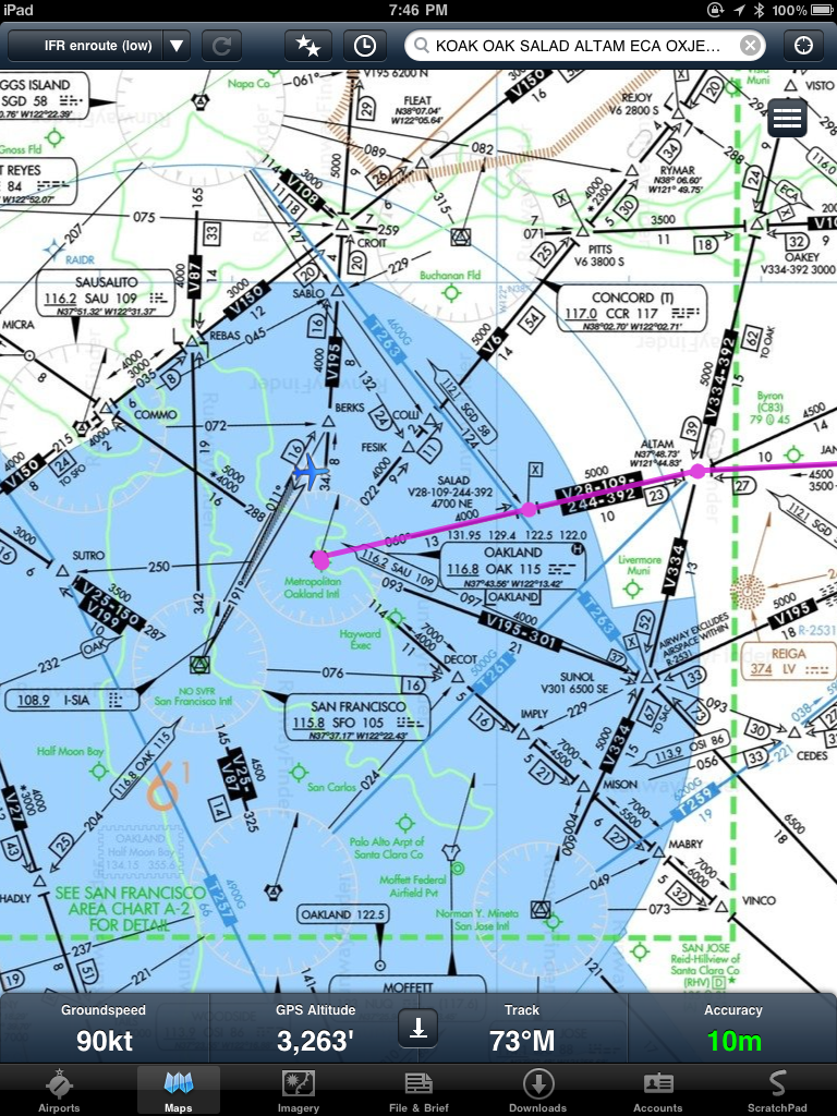
I tried the GNS 5870 with both FFM and SCP with good results. Headed down SF Bay on a flight from Oakland to Monterey, the FFM display showed 10 meter accuracy and both apps displayed ground speed and current track readouts that closely or exactly matched the values shown on the G1000 multi-function display (MFD) and primary flight display (PFD).

In the examples below, we were being vectored and then were told to proceed direct KNUQ which is why the G1000 course line and the FFM course line are not coincident.

G1000 MFD, Track Up
ForeFlight Mobile HD, North Up
Skycharts Pro offers the ability to display either North Up or Track Up and also provides the distance and bearing to the airport nearest to your current position, though bigger numbers would be easier on my aging eyes.

Skycharts Pro, North Up
Skycharts Pro, Track Up


The main advantage of the GNS 5870 is keeping your place on an en route chart displayed on an iPad. Neither FFM or SCP provide geo-referenced terminal procedures or airport diagrams, but both apps provide a subset of features you'd expect from a hand-held GPS receiver. SCP goes the extra mile and provides both desired track and current track as well as distance and time to the next waypoint. Neither app provides turn anticipation, a way to suspend waypoint sequencing, nor a way to define and display holding patterns.

Just as an experiment, I entered some of the waypoints that define the SCK RNAV (GPS) RWY 29R approach and found the GNS 5870's positional accuracy was quite good. The distance to the current waypoint actually matched the G1000 exactly, there was just a time lag between my taking the photo of the MFD and the iPad screen shot.


Both of these EFB apps display the GPS navigation data at the bottom of the iPad's screen and with the iPad in your lap you'll need to be vigilant about increased head-down time. Though the ground speed, track and GPS-derived altitude seem pretty accurate, I can't imagine using these displays to actually control an aircraft and I'm sure the developers (and their lawyers) would concur.


Conclusions

The GNS 5870 works well enough to make me consider trying one of the newer, lightweight RAM yoke mounts for the iPad to help ameliorate head-down tendencies. Guess I'll have to save more pennies and forego more soy lattes. The bottom line is that while this sort of GPS solution could help you avoid class bravo or visually acquire a unfamiliar airport, finding a runway at the end of an instrument approach is still the job for an IFR-certified GPS.

Related Posts Plugin for WordPress, Blogger...