Showing posts with label WAAS. Show all posts

Sunday, May 17, 2009

The Sky is Failing


If you read this blog very often you've heard me caution pilots about being overly reliant on any single method of navigation, like GPS. Since the GPS was declared fully operational in 1995, pilots, sailors, hikers, drivers, cell phone users, and the military all have become accustomed to the convenience provided by this no-cost system (okay, you have to buy the GPS receiver). Even the next generation air traffic control system NexGen, which the FAA has been furiously flogging as the panacea for everything from air traffic delays to tooth decay, relies heavily on GPS. But those plans might need to change.

A recently released GAO report entitled Global Positioning System: Significant Challenges in Sustaining and Upgrading Widely Used Capabilities has many wondering about the stability and sustainability of our constellation of GPS satellites, whether or not the Air Force can improve and "replenish" the system in time, and what our daily lives on the ground, at sea, and in the air might look like if GPS became unavailable or degraded.

The GAO's 61 page report is interesting reading, especially when compared to the glowing claims made by the FAA about the progress that's been made enhancing GPS availability and growing the number of RNAV procedures for aircraft. And if you are wondering if GPS is an aging system in need of repair or a robust system that continues to be expanded and enhanced, the truth probably lies somewhere in between.

One key questions that needs to be addressed is this: What is the useful service life of a GPS satellite? A solid answer is hard to come by, but one thing of which we can be certain of is that satellites have worn out in the past and more will wear out in the future. Of the current constellation of 31 GPS satellites, thirteen entered service between 1990 and 1997, twelve entered service between 1997 and 2004, and the remaining six satellites were launched between 2004 and 2009. That means about a third of the GPS satellites are between 12 and 19 years old; a sobering thought.

One of many problems that aging GPS satellites can experience involves clock errors. Since GPS receiver's position is calculated based on signals from several satellites, knowing the time each of the signals was sent and the time it was received is crucial. Each GPS satellite has four clocks that are periodically refreshed from the master station on the ground and each satellite will broadcast an estimate of time offset of the onboard atomic clock from the GPS system time. Since GPS signals travel at the speed of light, even minute errors in clock settings or offset estimates can result in large positional errors for GPS receivers. According to the GNSS Evolutionary Architecture Study released in February of 2008:
... large clock runoffs were experienced on SV22 [space vehicle #22] on July 28, 2001; SV27 on May 26, 2003; SV35 on June 11, 2003, and SV23 on January 1, 2004. These events generated range measurement errors of 1000 meters or more . The pseudorange error on SV22 on July 28, 2001, was reported to be 200,000m by some users and 300,000m by others.

Other problems that can afflict aging GPS satellite's include the failure of positioning components, propulsion systems, and a degradation of the power supplied by each satellite's solar array. The GAO report points out that the Air Force can often switch to a satellite's back-up system. And they can manage the power problem to an extent by powering down satellites when they are not needed or by shutting down power to "secondary payload" systems. These sorts of measures may extend the service life of older satellites, but it's clear that nothing lasts forever. New replacement satellites must be planned for and launched on schedule.

This leads to the GAO's main concern with the US Air Force's poor track record of creating and launching new satellites on schedule and within budget. Not only has the track record in Phase IIF been poor, the schedule for Phase IIIA actually compresses the lead time to produce and launch satellites. Without going into all the details of feature creep, government contractor inefficiencies, and the like, the bottom line is that the Air Force may not succeed and we GPS users may have to do with fewer satellites. Here's the GAO's estimate of how many satellites we may have to do with, or without. If they are right, the probability of having 24 functioning GPS satellites between 2010 and 2012 hovers around 85%.


The FAA's enhancement plans for GPS follows several phases and the FAA's aggressive creation of RNAV approaches with LPV minima in Phase II has been nothing short of astounding. Only a few years ago I was writing about LPV approaches from a strictly theoretical standpoint and now they outnumber ILS approaches. We are now in Phase III and a few of the stated goals are to :
  • Provide LPV approaches with 200' DA (most are currently 250 feet)
  • Transition support and enhancement of WAAS to the FAA
  • And prepare for an increase in predicted solar activity
The FAA appears to be doing a good job and enhancements to the WAAS ground components have significantly expanded WAAS RNP 0.3 availability.


And LPV coverage has been extended significantly, too.


Increasing GPS receiver accuracy using the Space-Based Augmentation System (WAAS) is obviously on track. People who study such things predict that there will be an increase in solar ionospheric disturbances beginning somewhere around 2022 and lasting for some number of years. Solar activity has reduced WAAS availability in the past and it's reasonable to expect it will happen again. Some have suggested that LORAN could be a back-up system, but for aviation that idea seems dead on arrival: There are few functioning LORAN units out there and no new units that I know of currently being manufactured for aviation use. The FAA has decommissioned many NDBs and they plan to decommission more (basically not fix the ones that fail). They'd also like to do away with most VOR stations. For better or worse, we seem to have put all our navigational eggs into the GPS space basket.

And the future could be very interesting indeed.

Friday, November 14, 2008

Curveball


Here's a great blog for pilots out there to read, especially this post. The Flying Penguine is written by an ATC trainee working in the Florida panhandle. The author works some pretty complicated airspace and does a nice job of conveying what it's like to deal with a mix of military and civilian aircraft while learning the ropes. Check it out!

A friend who works for a freight operator told of a controller interaction he had recently that highlights a problem for pilots flying technically advanced aircraft. Flying on an IFR flight plan, he was told by one controller to expect a particular approach. He pulled out the chart, briefed the approach, and loaded it into his GPS.

Handed off to the next sector, he was given a heading to fly that didn't make sense and was told to join the approach course. Confused, he asked for which approach the vector was intended. When the controller told him it was for a different approach than he had been told to expect, he realized all his careful preparation was for naught. He asked for a delay so he could reset his equipment, the controller dismissively told him he didn't have time for that. What he got instead is something pilots refer to as a punishment vector away from the airport. This resulted in a considerable delay - certainly more time than he needed. All of this occurred with the pilot flying single-pilot, at the end of his duty day, in IMC.

I'd been flying earlier that day and knew that, at some point, the winds changed and the Bay Area airports switched from the Southeast Plan to the more common West Plan. Something wasn't communicated between the two ATC sectors and the result was that my friend was set-up for a potentially serious problem. This illustrates that many controllers do not understand how important a pilot's set-up can be, especially if the pilot is flying alone. So what's a pilot to do when this sort of thing happens?

Non-standard phraseology is sometimes the best way to get a controller's attention and convey your current workload. Here's an exchange I had departing a holding pattern near Sacramento Mather:
"Cirrus 123, ready for the Rio Vista GPS 25 approach, Travis information delta."

"Cirrus 123, roger, fly heading 240, when able, proceed direct EPPES"

"Heading 240, direct EPPES when able, Cirrus 123"

And 30 seconds later ...
"Cirrus 123, are you direct EPPES at this time?"

"I will be as soon as I finish twisting some knobs and pushing a few buttons, Cirrus 123"


First, don't be bashful about explicitly telling the controller that a clearance is unacceptable. Be polite, but be clear. You may be at too high an altitude, going too fast, or you might need to avoid some unsafe weather. By immediately telling ATC that a clearance won't work, you actually save everyone some time, especially if you can offer an alternative or two. Few things are more dangerous in single-pilot IFR than pressing on, trying to make a bad situation work.

When setting up for an approach, it's a good practice to have all the relevant approach charts readily available. The last thing you want is to be searching for an approach chart at a high workload moment. When I flew freight, my standard procedure was to have these approach charts available before arriving at Oakland.
  • OAK ILS RWY 29
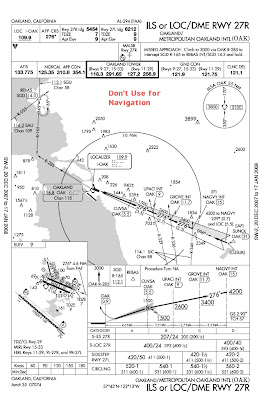
  • OAK ILS RWY 27R
  • OAK RNAV RWY 27R
  • OAK RNAV RWY 27L
  • OAK VOR/DME 27L
  • OAK VOR 9R
  • OAK RNAV 9L
In my case, having the Oakland VORTAC tuned and identified was useful in maintaining situational awareness regardless of which approach I was anticipating. If you think this is overkill, remember that even when the Bay Area is on the Southeast Plan and Oakland is landing runways 11 and 9 left/right, it is often possible (and expedient) for light aircraft to fly the ILS RWY 27R approach and circle to another runway. Having RNAV, VOR, and ILS approaches ensures that you're prepared, even if a navaid goes out of service unexpectedly.

The same principle applies when departing an airport. You may have the SID or departure procedure out, but if your aircraft develops an unexpected problem it sure would be nice to have one or more approach charts ready for an unexpected return. Yet I seldom see pilots prepared for an emergency return to their departure airport.

To handle the unexpected in a technically advanced aircraft, you must be adept with the knob twists and button pushes required to:
  • Select an approach
  • Activate a leg on the intermediate approach course
  • Proceed direct to a fix on the intermediate approach course
  • Activate vectors-to-final
  • Recognize where you are on the approach
  • Quickly select and load another approach, perhaps to a different airport

We tend to assume that a moving map display makes it child's play to know your position on an approach, yet I often see instrument pilots make the crucial mistake of descending below a minimum altitude because they thought they'd passed a fix. So here are some suggestions on ways to improving situational awareness with the G1000 when flying an approach with a lot of stepdown fixes, like the Jackson Hole RNAV (GPS) X RWY 1 approach.


Some pilots keep their situational awareness by displaying the flight plan on the G1000's MFD, which provides a lot of details, like crossing altitudes. Unless you are flying with another pilot in the right seat, this requires more head turning since the MFD is not in your primary field of view. I prefer displaying the flight plan in the inset window on the PFD, which shows the active waypoint and the distance to that waypoint.


You can also set one of the bearing pointers to the GPS. This will display the name of the current waypoint and the distance to that waypoint in your primary field of view. If you've activated a leg of the approach to intercept, the bearing pointer will show the distance to the waypoint closest to the airport. Setting a bearing pointer to the GPS also works well if you have activated the approach with the Vectors-To-Final option. While you're being vectored, the bearing pointer will point to the current waypoint, the final approach fix, just like an ADF would if the FAF was a locator outer marker.


The GPS bearing pointer trick is also helpful when you need to display something that will make the flight plan inset window go away, like the timer window.


If you are practiced at using your GPS, have all the necessary charts at the ready, and aren't bashful about what clearances will and won't work, you'll be better prepared to handle the occasional unexpected curveball.

Saturday, May 10, 2008

Muddy Boots

Rubber Boots + Muddy Holes = Muddy Boots

So goes the memory device used to remember the formula for calculating the magnetic bearing to an NDB station. The formula is: Relative Bearing + Magnetic Heading = Magnetic Bearing to the station. Let's forget for a moment that no one actually uses this formula in the air while performing Automatic Direction Finder (ADF) navigation. We're talking about a sacred aviation tradition here!

My recent comments about non-directional beacons (NDBs) and the FAA's test questions about them drew some emails from a several readers. Yes, there are still a few pilots out there who actually like using NDBs. For all we know there may even be a few pilots still alive who have fond memories of the A-N range system, though it's hard to carry on a conversation with them since they all went deaf listening to the static and the A-N tone while trying to stay "on the beam."

Let's set sentimentality aside: NDBs and the ADF receivers that use their signals are not terribly accurate and we have significantly easier-to-use navigation systems, namely GPS. With all the emphasis on GPS/WAAS, many pilots seem to have forgotten (or they never learned) that GPS also relies on ground-based facilities. WAAS requires a series of ground stations to calculate the correction messages that provide the 3 meter accuracy offered by differential GPS. In fact, the GPS satellites themselves depend on ground-based support in order to function properly.

The possibility of a GPS failure at a systems level, however remote that might be, is something that many pilots simply don't want to consider. And many pilots don't understand that GPS receivers can and do fail. So while I'm not sentimental about NDBs and LORAN, on more than one occasion it was a lowly ground-based VOR, NDB or marker beacon that saved my bacon when my GPS receiver failed. So the big deal with ground-based navigational aids like NDBs, marker beacons, and LORAN is that they provide something that should be of interest to all pilots - redundancy.

Every few years, the FAA insists that VOR stations will eventually be phased out. Many NDBs have been or are slated to be decommissioned. I don't have access to an aircraft with a functioning LORAN receiver, but I know at least one pilot who does and uses it regularly as a backup. Even marker beacons are being eliminated, presumably to save money, though strangely the old CASES outer marker (which used to be part of the Oakland ILS RWY 27R) still continues to function even though it is no longer associated with any instrument approach or departure procedure. Think about that for a minute - the real estate is still being used, the antenna is still there, and the marker beacon transmitter is still functioning, it's getting electrical power, the electric bill is being paid by someone (probably taxpayers): Talk about the lights being on and no one being home!

Personally, I like the situational awareness that an NDB provides when it is associated with an ILS approach because the ADF needle points in the general direction of the final approach fix. Unlike other radio navigation systems, the ADF provides instant situational awareness once you accept that the needle usually-kinda-sorta points to the station. Virtually all of the planes I fly do not have an ADF or the ADF is broken, so what's a G1000 pilot to do if they want to maintain proficiency in using ADF-style navigation?

If you're getting vectors to intercept an ILS and you've selected the Activate Vectors to Final option, you can get the G1000 to emulate the behavior of an ADF by pressing the PFD softkey, then selecting one of the bearing pointers to use the GPS.


With vectors-to-final selected, the current GPS waypoint is the final approach fix and the bearing pointer will act just like an ADF needle, albeit much more accurately. In the example below, it's pretty easy to see that you are on a left base vector to the localizer.


The ADF-style pointer is also a great way to see when the controller has forgotten about you and you are about to go through the localizer.


A big advantage with the G1000's bearing pointer is that it is superimposed over a slaved heading indicator. Most of the older ADFs in GA aircraft have a fixed card or moveable card that is not slaved. It's even possible to practice NDB-style navigation to any waypoint you choose, so enterprising instructors can still expose instrument students and pilots to a bit of aviation tradition. You can practice wind correction angles, tracking bearings to and from the waypoint, the whole enchilada. You won't even have to get your boots muddy.

Friday, April 25, 2008

How Low Can You Go?


Continuing with the IFR minutiae of my last few posts, a regular reader asked a question about the new GNSS MEA (Global Navigation Satellite System Minimum En route Altitudes) that are starting to be depicted on low altitude en route charts. So what are these new MEAs, why do they exist, and when would you use them?

Traditionally, a minimum en route altitude on an airway was the lowest altitude at which an aircraft could be operated under IFR and still have adequate ground-based radio navigation reception and two-way radio communication with ATC. There sometimes is a lower altitude published that can be used - the Minimum Obstruction Clearance Altitude - but you need to be within 22 miles of the ground-based navigation station that defines the route segment and no guarantee of two-way radio communication with ATC is provided.

"Special MEAs" were first developed in Alaska under the Capstone project (the precursor to the NextGen system that will supposedly change the National Airspace System). The purpose of these Special MEAs was to allow aircraft to fly at lower altitudes on an airway to stay out of icing conditions while still providing two-way communication with ATC and adequate obstruction clearance. The new GNSS MEAs seem to be an extension of this concept to the lower 48 states in the U.S.

You may be wondering why these new MEAs are called "GNSS MEAs" (Jeppesen uses the term "GPS MEA"). GNSS is an international standard and the U.S. GPS/WAAS is just one implementation of that standard, or at least it will be when all the international requirements are met. As we used to say in the software world - "The nice thing about standards is that there are so many of them." One reason this distinction is important is that WAAS coverage in the U.S. GPS system, which depends on ground-based reference stations, is not designed to provide world-wide coverage. So while you may be able to use your GPS in Nepal, don't expect to have the additional accuracy that differential GPS (WAAS) would provide if you were located within its service volume.

To use these new, lower GNSS MEAs, it's not clear if your aircraft must be equipped with an appropriate, IFR-certified GPS/WAAS receiver (TSO C145a and TSO C146a), which would include the Garmin WAAS-enabled G1000, GNS 530W/430W. Older, non-WAAS GPS receivers with RAIM capability (TSO C-129), including the non-WAAS G1000 and the GNS 530/430 may also be okay since there are no regs I can find saying they aren't okay for this lower MEA. The latest version of the Instrument Procedures Handbook doesn't provide any information or guidance on GNSS MEAs. Jeppesen airway manuals use different terminology and contain only a brief description.
U.S. GPS MEAs
GPS MEAs are supplemental to and lower than the regular MEA. GPS MEAs are not established for every route, or for every route segment. The absence of a GPS MEA means one has not been provided and the regular route MEA applies. A GPS MEA may be higher than, equivalent to, but not lower than a Minimum Obstruction Clearance Altitude (MOCA) associated with a given route segment.


GNSS MEAs are depicted in blue with a G suffix, such as 4000G for a 4000 foot MEA for GPS/WAAS-equipped aircraft. The IFR Chart User's Guide published by NACO offers a brief description.


For their part, AOPA is lobbying for GNSS MEAs on one T-route in Oregon that would only provide adequate obstruction clearance without two-way radio communication with ATC. The idea is to provide the absolute lowest altitudes in an area where airframe icing is particularly prevalent, but doing so would introduce a new-to-me concept: An airway MEA that could only be used by one aircraft at a time, similar to the way class E airspace around a non-towered airport is reserved for one IFR aircraft at a time.

While there is a WAAS service model for the U.S. that is used to predict degradations in WAAS service that may affect RNAV approaches, only the larger airports have WAAS NOTAM service. This means that if you plan to fly an RNAV approach into an airport without WAAS NOTAM service or if you plan to use a GNSS MEA, you'd best be using an approved Fault Detection/Exclusion program during your preflight planning. And you best have a plan B, too. Right now, how WAAS outages might affect the use of GNSS MEAs during en route navigation does not seem to be very well thought out.

Wednesday, March 26, 2008

Approach Planning

The morning fog and stratus pulled back to the center of Monterey Bay, there were only few aircraft in the area, and that gave me time to ponder all the flights I made through this area in my freight hauling days. It brought back a lot of memories - some good, some not so good. But we weren't hauling freight. Our purpose was to provide a little variety during instrument training by mixing some VFR flying across San Francisco Bay with a couple of instrument approaches into Watsonville.

There was initial confusion on the part of a ground controller who sounded like one of many new arrivals to Oakland's North Tower. We'd briefed the VFR transition over the San Mateo Bridge mid-span prior to starting the engine. The briefing included the transition from Oakland's North Field over the South Field, the importance of staying well clear of San Francisco's Class B surface area as well as underneath the overlying Class B, and the existence of a defined VFR waypoint (VPMID) for the San Mateo Bridge mid-span. I'd said to plan for an initial altitude restriction of 1400 feet, but the new ground controller (who was also working tower) gave us a 2000 foot restriction. When handed off to the South Tower at 900 feet, the South Tower controller (a seasoned veteran) queried "Were you given an altitude restriction?" When we told her 2000 feet, she corrected that to 1400 feet.

A few minutes later, we were handed off to the first of several Norcal sectors and were gradually allowed to climb higher as we motored over the Sunken Ship, past Palo Alto and over Moffett Federal Air Field (a former Naval Air Station). A few minutes later, the Lexington Reservoir was beneath us and a bit later, just clear of the Santa Cruz Mountains, we began the descent just to the east of Capitola.


My student had told Norcal that we were "direct NALLS for a practice Localizer 2 approach into Watsonville, with the one-minute weather." The plan was to do the procedure turn on our own navigation, fly the approach to as close to minima as the VFR traffic at Watsonville would allow, then fly the published missed approach and hold over Salinas (a holding pattern I know all too well). After the holding pattern, we planned to fly the GPS A approach because it offers a DME arc and there are precious few of those in Northern California that are also close to the Bay Area.


As we were outbound in the procedure turn, I remembered why the LOC RWY 2 approach sets off my spidey senses: We were beyond gliding distance from the shoreline, over waters frequented by great white sharks, in a single-engine piston aircraft. So I distracted myself by looking for traffic and pondering the other instrument approaches into Watsonville.


If the coastal stratus has blown in, the Localizer RWY 2 approach may be your only real hope of getting into Watsonville because it is the only approach that will probably get you below the clouds - 680' MSL. There is an NDB or GPS B approach that is lined up with runway 2 that gets you almost as low as the Localizer approach - 900' MSL. The VOR/DME or GPS A approach from the southeast that only gets you down to 1300 feet, which is often just above the tops of the stratus layer.


When flying an aircraft with a WAAS-enabled GPS receiver, the WVI GPS B approach is in some ways more attractive than the Localizer RWY 2 approach. One reason is that the G1000 will provide you with a vertical track on the GPS B approach down to the final approach fix (FAF). After the FAF there's no descent guidance on the GPS B, but you don't get any descent guidance whatsoever with the localizer approach. The other advantage of the GPS B approach is you needn't end up as far out to sea when you make your procedure turn as you probably will with the LOC RWY 2 approach.


There are probably many other cases where a RNAV (or GPS) approach gets you lower or offers advantages over a localizer approach - South Lake Tahoe comes to mind. So when you are considering which approach to fly into an airport, don't forget to examine all your options. The advantages of one approach over another is not always as simple as it seems.

Friday, January 4, 2008

VTF or WTF?

Many pilots are confused about who's responsible for terrain and obstruction clearance on a vectored approach, so here's the skinny: As long as ATC is vectoring you, they are responsible for guaranteeing obstruction clearance. Once you are established on and cleared for the approach, you are responsible for your own obstruction clearance by flying the altitudes on the approach chart.

Your approach clearance will contain the following item which you can remember with the acronym P-TAC:

1) Your Position (distance) relative to a fix or waypoint on the approach
2) Heading to Turn to or maintain
2) Altitude to maintain until established
3) Clearance for the approach.

Once you are established, comply with all crossing restrictions listed on the approach chart and you shouldn't run into anything. If there are intermediate approach fixes, you must be prepared to identify those fixes so you can maintain the appropriate altitude.

If there are several intermediate approach course fixes (IF) before the final approach fix (FAF), you're probably executing an instrument approach procedure to an airport surrounded by mountainous terrain or close to another airport that also has instrument approaches.

For non-RNAV approaches, a controller can vector you to most any point on the intermediate approach course, then give you the approach clearance. The controller's handbook says they are supposed to vector you no closer than 3 NM from the FAF with an intercept angle not to exceed 30˚ and that's usually what they do - but not always.

For RNAV approaches, controllers are restricted from vectoring you to a point inside an intermediate fix (IF). They should get you in a position where they can clear you direct to an IF with an intercept angle of 90˚ or less. And since you are RNAV (or GPS) equipped, you then resume your own navigation to the approach course and intercept it on your own.

Continuing on the previous discussion about Garmin's implementation of Vectors-to-Final for instrument approaches, I stumbled onto a way to get the Garmin 430/530, 430W/530W, and G1000 to display all intermediate approach fixes when being vectored to the final approach fix.
For the G1000, consider the Oakland ILS or LOC DME 27R:


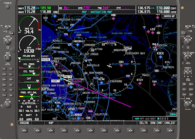
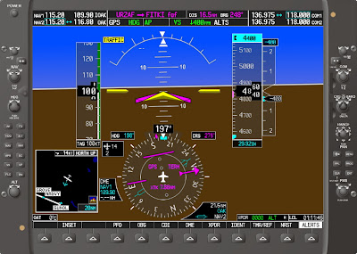
I've seen many pilots hear a controller say "Fly heading 180, vectors for the ILS 27R," load the approach, see the "Vectors to Final" approach option, and then, almost unconsciously, select that option. For this approach, this is what you get when you select Vectors to Final. When the controller says "Barnburner 123, three miles from GROVE, cross GROVE at or above three thousand four hundred, cleared ILS 27R" you're now left trying to figure out where GROVE and UPACI are located.


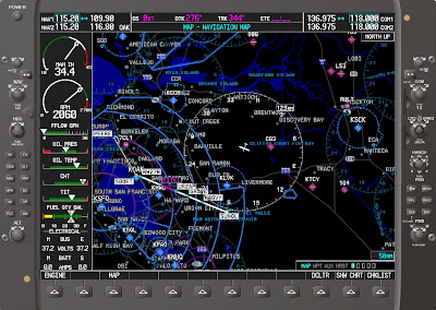
Wouldn't you rather see this?


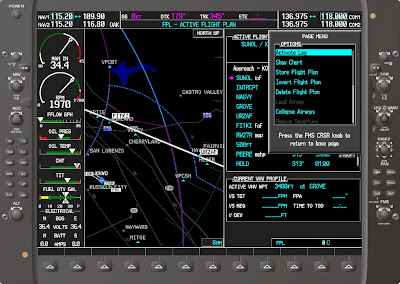
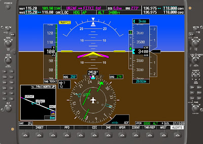
Here's how: Load the approach with the initial approach fix instead of vectors to final. Press the FPL button, press the small FMS knob to enter cursor mode, scroll with the large FMS knob to the final approach (FITKI in this case), press the MENU button, Activate Leg will be highlighted by default, press ENT twice, and you're good to go. This same sequence will also work with the Garmin 430W and 530W. The older Garmin 430 and 530 require a different sequence sequence, covered below.


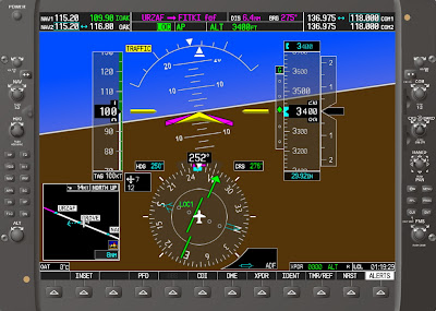
If you're wondering how this setup works with the Garmin autopilot, the answer is "very nicely." Just set the heading bug to your assigned heading, activate the autopilot in HDG mode, and press the NAV button. The autopilot will stay on the assigned heading until the course comes alive, then it will turn and intercept.


As you approach the localizer course, the nav source will automatically switch from GPS to LOC.


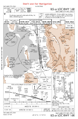
To get the intermediate fixes to display the Garmin 530 or 430, the sequence is a bit different. For this example, let's consider the Salt Lake City ILS RWY 16R, which has three intermediate fixes outside the FAF.


Load the approach with OGD or FANDS as the transition: It doesn't really matter which one you choose.


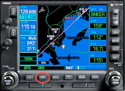
Activate the approach and you'll be dumped into the flight plan view. Press the small knob to enter cursor mode, scroll with the big knob and highlight BNKER (the FAF), then press MENU.


The Activate Leg option is highlighted by default, so press ENT twice.


This view gives you pretty much what you need, but if you want to see the magenta line extended out farther, there are a couple more steps.


First, make sure your OBS or HSI is set to the localizer front course.


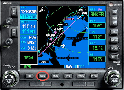
Next, press the OBS button and you'll see the magenta line extended outward. Small problem, the intermediate fixes have disappeared.


Press the OBS button again and like magician David Copperfield, you've reversed the disappearing act and the IFs are shown again.


Wouldn't it be nice if this was done automatically for you? WTF?

Sunday, December 9, 2007

Everyone Has to Be Somewhere

Here's a fascinating exchange I heard while flying an aerial survey mission a while back.
Norcal: Mooney 123, use caution, several aircraft have reported numerous hang gliders in the vicinity of Mission Peak.

Mooney: Ah, what altitude are those hang gliders?

Norcal: Mooney 123, they don't show up on my radar, I have no idea.

Mooney: Ah, where is Mission Peak?

Norcal: Mooney 123 your current location is Mission Peak.

Several improvements have been made to the G1000 and to the G1000 simulator software. At this writing, the most recent Cessna airframe G1000 simulator is version 8.01 and it contains some very useful features. One is the new dual mode operation that allows you to display both the Primary Flight Display (PFD) and Multi-Function Display (MFD) simultaneously on your computer screen. You can also resize the screens, just in case you don't have a dual monitor setup. It seemed like just a matter of time for this to be offered.


Since the real G1000 has two computers (PFD and MFD) connected by ethernet, it was natural to assume that two simulator processes could be launched on one computer and interconnected using a local socket. This appears to be what Garmin did, but be advised that the computer horsepower to run this setup is not trivial. Choosing the TAWS option before starting up the simulator basically brought my machine to its knees: Red Xs appeared and disappeared on the PFD indicators and a voice would say "TAWS not available," then a few seconds later "TAWS available," then a few seconds later "TAWS not available" ... over and over. I'd recommend against selecting TAWS unless you have a seriously fast computer with a good deal of memory.

While shortcuts for the standard simulator are automatically created, you have to dig a bit to locate the BAT file that allows you to launch the dual-mode version.


The new version of the G1000 simulator allows you to experiment with the Garmin autopilot/flight director that Cessna chose to not make available on the lowly C172. It also lets you try out the new Victor airway-based flight planning. I'll provide an overview of this feature using the flight planning interface provided on the MFD. A similar, but simplified flight plan interface is provided on the PFD.

Assume you receive the following clearance:
Cessna 12345 is cleared to Reno, on departure, fly heading 310, radar vectors to V6, Squaw Valley, direct. Climb and maintain 5000 ..."

Start by entering the OAK VORTAC after the departure airport. This is important because you can't load an airway unless the preceding waypoint is either a VOR or an intersection on an airway. Then position the cursor on the empty line following the OAK VORTAC and press the Menu key.


A menu appears and you'll need to scroll (I recommend always scrolling with the big FMS knob by default) to the Load Airway menu item and press the Enter key.


Another menu will appear listing all the Victor airways and Jet routes associated with the OAK VORTAC. Select V6 and press Enter.


Yet another menu appears listing all the terminating waypoints for Victor 6. Select SWR (Squaw Valley) and press Enter.


One last dialog appears asking you to confirm that you want to load the airway. Like you'd go to all this trouble by mistake and not want to load the airway? Press Enter to confirm and the airway, along with all the changeover points on that airway, will be added to your flight plan. To help you decide which terminating waypoint to use, the map view next to the flight plan window changes to display the location of the terminating waypoint that you've highlighted.


Changeover points on an airway are often explicitly marked, but just as often they must be identified on a chart by subtle bends in an airway or by a halfway point between two VORs. The big time savings in the G1000's airway-based flight planning feature is that you don't have to stop to figure out changeover points using a paper chart, which is quite useful indeed.

Unfortunately, you can't select an airway, then select another intersecting airway: You must select the waypoint those two airways haven in common, load the first airway, then go through the whole process again for the next airway.

An aside, I find Garmin's use of confirmation dialogs to be both tedious and inconsistent. Frankly, when you're consumed in a classic, heat-of-battle-single-pilot-IFR crisis moment, these dialogs are real time wasters. You go through a bunch of knob twisting to load an airport or a waypoint and it asks you are you sure? But inadvertently press the small FMS knob instead of Enter (which I have seen pilots do countless times) and you're unceremoniously dumped out of whatever you were doing and all the letters you've painstakingly entered are destroyed. Garmin's whole large knob, small knob selection interface has to be one of the worst designs I've ever seen and they continue to propagate it forward when they implement new features, like checklists (which I'll talk about in a future post). But since it's what they provide, I guess we pilots have to hold our noses and just use it. Lucky for us, many of the G1000's other cool features makes it easier to take Garmin's silly user interface faux pas.

Tuesday, October 30, 2007

G1000 Update


I have the luxury of flying a new C172 with a G1000 that regularly returns to a Cessna Service Center for 100 hour inspections and sundry maintenance. As a result, the software on the G1000 has gone through some changes as the service technicians applied the latest updates. I'm talking about updates to the G1000 software itself, not just the various Jepp, terrain/obstacle, electronic charts, and electronic checklist databases. In particular, two of the changes were most welcome.

The first is that when the Multi-Function Display (MFD) is power up, you no longer have to wait for the expiration dates of the various databases to scroll by in the Star Wars fashion. You know, the scrolling text "Long ago, in a galaxy far away ..." It literally used to take several minutes for this stuff to be displayed. Now you just see this screen:


The other cool feature of note is that should either the Primary Flight Display (PFD) or the MFD fail, you will now still have the inset map displayed on whichever screen is left. This is a huge improvement to situational awareness and makes the G1000 reversionary mode practice (nee "partial panel") pretty easy to perform. In fact, you have so much information compared to a steam gauge partial panel scenario that it's almost obscene. So easy that I found myself saying to one of my instrument students "In the old days, we just had the CDI, turn coordinator, altimeter, and the compass ..."


Too bad Garmin doesn't display the ground speed on the remaining display. It's kind of amazing that they don't, given that ground speed on a partial panel, non-precision approach is one of the most useful things you can have. There's plenty of screen real estate there, so maybe they'll add it in a future update?

Monday, September 10, 2007

New Publications

Visit the FAA's website and you'll find a revised version of the Instrument Flying Handbook that has finally caught up with modern avionics. The new handbook shows instrument attitude flying techniques for glass panel aircraft, discusses autopilots and flight directors, and terrain and weather systems. The book contains a lot of new, four-color illustrations. They even have color representation of ALSF-I and ALSF-II approach lighting systems. And best of all, you can download it for free.

There's also a document I had not seen before - Powered Parachute Flying Handbook.

Check it out!

Tuesday, July 10, 2007

Flying in a 'lectronic World, Part II

Virtually all aviation GPS equipment manufacturers have failed to acknowledge that pilots fly aircraft in three dimensions, not just two. Granted, low-altitude IFR en route charts, high-altitude charts, and area charts by their very printed-on-paper nature are two-dimensional. Approach charts provide the third dimension (altitude) in a crude way using a profile view. And on non-precision approaches, IFR-certified GPS units seem to have been specifically designed to provide no vertical navigation at all, not even an awareness of step-down altitudes, which was left up to the pilot. But with the new WAAS-enabled G1000, it looks a new era has begun.

Computing accurate rates of descent or climb is a really good job for a computer, especially in single-pilot operations where the pilot has other things to occupy his or her time and where descending too soon, or too rapidly, can be dangerous. The new G1000 lets you enter a desired altitude for each waypoint in a GPS flight plan along and here's the radical part: A Vertical Descent Indicator (VDI) and Required Vertical Speed Indicator (RVSI) will appear on the primary flight display and actually provide vertical guidance based on your current ground speed. This is something that pilots have needed since the inception of IFR GPS and in most units has only been available in a very rudimentary form, usually limited to just one flight plan waypoint. Not any more.
The G1000 flight plan interface on the Primary Flight Display (PFD) is much more simplified than the Multi-Function Display (MFD). As you're creating your flight plan (or when editing an existing flight plan), you may notice that the MFD's flight plan interface on the new G1000 contains altitude fields. Press the small FMS knob, scroll with the large knob to the field where you want to enter a value, then turn the small FMS knob to start entering an altitude or offset.


An annoying feature is that you enter altitudes one digit at a time, starting with tens of thousands of feet: Turn the small FMS knob to set each digit and scroll to the next digit with the large knob. And when you are done entering a value, press ENTER to save the value. If you press the small FMS knob (which I have seen pilots do thousands of times), you'll jump out of cursor mode without saving anything. This is infuriating if you've just invested several seconds entering an altitude. Garmin perfected the same sort of dumb user interface policy in the 430/530 products. You'd think they would have come up with a simpler, more efficient, and more intuitive way ...

The new G1000 also has an Along Track Offset (or ATK OFST) feature. The name may be counterintuitive, but enter the Flight Plan page, press the small FMS knob, use the big FMS knob to highlight the flight plan waypoint for which you wish to specify an altitude, then press the ATK OFST button. You can now specify a distance from a waypoint and a crossing altitude, which results in the creation of a new waypoint in the flight plan. The name of this feature may be dumb, but the feature itself is quite useful.


The Avidyne CMax chart display is pretty good in that in shows your position on the actual chart (circled in red), but accessing a chart requires a strange sequence of button pushes. And navigating back out of the chart display is equally convoluted.


The G1000's NACO chart display is similar to the electronic charts provided on the Cirrus' Avidyne, but these charts aren't a substitute for paper charts. The G1000 provides a soft key (circled in red on the lower right side of the MFD) that makes it very easy to display these charts from the map view and then quickly return to the map view, but there are several disadvantages. The NACO charts don't show your current position on the approach chart like the CMax displays do. When you display a NACO chart on the G1000, the moving map display goes away as does your terrain awareness and the TIS traffic display. Some of this information can still be displayed in the inset map on the PFD, but that inset map is pretty small.


One of the coolest features of the new G1000 is it's ability, when coupled to the KAP 140 autopilot, to automatically fly course reversal and holding pattern entries. For this to work, the holding pattern must be part of a defined procedure: The G1000 doesn't allow you to specify your own holding pattern like the older GNS480 does. Here is a sequence of photos of the G1000 and KAP 140 autopilot flying the SCK ILS RWY 29R by proceeding direct to the SC LOM, flying a teardrop entry, and finally getting established on the localizer.


If you are flying a GPS or RNAV approach, the G1000 and KAP 140 should automatically fly the course reversal and get you established on the intermediate approach course. You'll have to initiate the descent using the autopilot and I still have not discovered why the KAP 140 will not fly a GPS glide path.

If you're flying a localizer, ILS, or VOR approach, there's a catch. Anytime the nav source is changed when the KAP 140 is engaged in NAV mode, the autopilot will automatically switch from NAV mode to ROL mode (wings level). If you load, say, an ILS approach the G1000 will automatically switch the navigation source from GPS to the VOR/LOC receiver prior to the final approach fix causing the KAP 140 to go into ROL mode. The only indication that the autopilot is no longer tracking a NAV source is the NAV annunciator on the KAP 140 will flash to prompt you to reselect NAV (or approach) mode. The ROL annunciation will display, too, but the autopilot's display is not really in the pilot's primary field of view and there is no aural warning to get your attention. If you don't manually select NAV mode again on the KAP 140, the autopilot will not track the newly selected nav source and you could find yourself flying off course in short order. The new Garmin autopilot may handle the change of nav source without a problem, but did I mention that it is not available on the Cessna 172? I think I did ...
Related Posts Plugin for WordPress, Blogger...