


 NOTE: For a more up-to-date discussion, see Understanding RNAV Approaches.
NDBs are being phased out, GPS manufacturers are claiming that soon everyone will fly precision approaches to airports with virtually no specialized equipment on the ground, GPS approaches with vertical guidance are being created at an impressive rate, Garmin has finally certified the long-anticipated WAAS upgrade for their popular 430/530 GPS receivers, and the FAA says in the Instrument Rating Practical Test Standards that a GPS approach with vertical guidance is still considered a non-precision approach.
Yes, the aviation world has gone crazy.
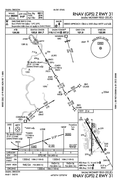
If you need more evidence, look at this approach chart and you'll see three different approach minima: LPV, LNAV/VNAV, and LNAV. To understand which minima apply to the aircraft you are flying, you'll have to jump into the alphabet soup. First, here's my take on the history of RNAV which I think is relatively accurate.
 Back in the late 1970's and early 80's, RNAV units (think "aRea NAVigation) like this King KNS-80 were the coolest thing since sliced bread because they allowed a pilot to create waypoints (colorfully referred to at the time as "phantom stations") based on DME distances (called Rho) and VOR radials (called Theta). And no one seemed to mind much that using these units often required a lot of button pushing and knob twisting. And as reliable and affordable Rho-theta navigational systems became available, the FAA began developing approach procedures for these units called RNAV approaches.
In large, expensive aircraft, multi-sensor Flight Management Systems (FMS) became widespread. These FMS utilized a variety of ground-based navigation aids, combined with inertial reference units, to provide seamless and accurate navigation.
When IFR-certified GPS units came along and the FAA began creating GPS approaches, they were worried about reliability. So they created GPS approaches that overlaid existing VOR or NDB approaches and required the pilot to have the other navigational equipment on board and to monitor that equipment during a GPS approach. Gradually the FAA became convinced that GPS was maybe pretty good, they no longer required the pilot to monitor the other navigation systems, and they even created (gasp!) stand-alone GPS approaches where GPS was the primary means of navigation.
I won't even go into LORAN, a land-based radio navigation system that seemed to fall out of favor for air navigation quicker than you can say "decommissioned NDB." And as FMS and IFR-certified GPS units became widespread, the FAA decided that it needed a broader category that would contain Rho-theta systems, FMS, and GPS. Rather than come up with a new term, the existing term RNAV was redefined to include them all.
To accommodate both FMS and GPS-equipped aircraft, approaches started being created with titles like RNAV (GPS) RWY 31. In some cases, there was more than one version of an RNAV (GPS) approach to the same runway and the title had to have a suffix added like Z or Y added to the end to get around the limitation in many FMS databases that precluded more than one approach having the same name.
ICAO standards began to be formed for Required Navigational Performance (RNP) to describe the accuracy required of air navigational systems for different phases of flight. Recently, RNP approaches have been created for specially authorized aircraft and flight crews that combine curved approach and departure paths with reduced obstruction clearance that some might call spine-tingling. And in classic, confusing fashion, the term RNP, initially developed to describe the accuracy of navigational systems, was appropriated as an approach classification, too.
The nice thing about standards is that there are so many of them.
So where are we today? RNAV includes any IFR-certified GPS, multi-sensor FMS (many include GPS in the array of navigational sensors), or approved Rho/Theta unit (like the now ancient KNS-80). I won't go into which equipment suffix you add to your aircraft because that depends or whether or not your aircraft meets the new Reduced Vertical Separation Minima standards. We now have RNP approaches (requiring special aircraft and aircrew training and certification), RNAV (GPS) approaches that can be flown with an IFR-certified GPS or the appropriate FMS, standalone GPS approaches, GPS overlay approaches (with titles like VOR or GPS A), and all the standard VOR, ILS, LOC and NDB approaches. Eventually, all standalone GPS approaches with names like GPS RWY XX will be renamed RNAV (GPS) RWY XX. So now that it's established, at least for now, what RNAV means, take a look at the different minima on RNAV (GPS) approaches.
For aircraft with older IFR GPS units certificated under TSO C129A1 (not WAAS-enabled), you're stuck with LNAV - lateral navigation - minima. This means you'll fly a non-precision approach with a Minimum Descent Altitude (MDA) and a visibility restriction. In the U.S., visibility ultimately determines whether or not you can legally descend below the MDA and land. If you have a GPS certificated under TSO C145A or C146A (WAAS-enabled), you can use the LNAV, LNAV/VNAV, or the LPV minima. In case you're wondering, LPV (according to the Aeronautical Information Manual's glossary of terms) stands for "Localizer Precision with Vertical guidance." There is also the acronym APV - which seems to be a broader category - Approach with Vertical Guidance. Interestingly, the FAA's Instrument Procedures Handbook says that LPV is not an acronym - our tax dollars at work! Anyway, the topic at hand is knowing which set of minima to use.

Since I have yet to fly an aircraft with a GPS unit certified under TSO C145A or C146A (aka WAAS-enabled), I have been reading the new manual for the Garmin 530W (WAAS-enabled) and it contains some enlightening details. Using the 530W, you load the KSLE RNAV (GPS) approach just as you would any other GPS approach, specifying the Initial Approach Fix you wish to use to transition to the approach or the Vectors-to-Final option if ATC is guiding you to the intermediate approach course.

Two miles from the Final Approach Fix (LOTKE), the CDI sensitivity will begin to change from TERMINAL mode (full scale CDI deflection representing 1.0 nautical miles) to an angular course width of 2˚ or the width specified for the approach. Sixty seconds from LOTKE, the receiver will check the Horizontal Arm Limit (HAL) and Vertical Arm Limit (VAL) to determine if there is sufficient GPS course integrity to perform the LPV approach. If there is sufficient integrity, you'll see the TERM annunciation in the lower left of the 530's display change to LPV and that, along with a glide slope indication on your CDI or HSI, is your cue to use LPV minima. You should intercept the LPV glideslope just as you would an ILS glideslope and descend to the Decision Height shown on the chart before landing or executing the missed approach procedure.
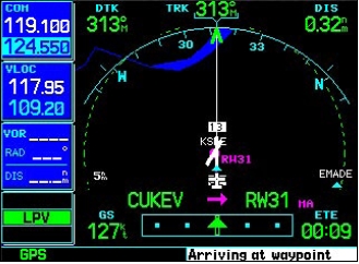
If there isn't enough course integrity to provide an LPV approach (did you check GPS NOTAMs prior to takeoff?), the annunciation will change to LNAV and you'll see a message "Approach downgraded - use the LNAV minima." The Garmin manual refers to an LPV approach as a "precision approach" in spite of the fact the FAA currently still considers an LPV approach to be a non-precision approach. And if the course integrity isn't sufficient for an LNAV approach, you'll see a message telling you to abort the approach, the annunciation will change to TERM sensitivity, and you should climb, fly to the Missed Approach Point, and then execute the missed approach procedure.
Since you might not know which set of approach minima will apply to your approach, how do you request the approach? The FAA's Instrument Procedures Handbook says that if the approach has a title like "OAK RNAV (GPS) RWY 27R", you should tell ATC "request the Oakland RNAV 27 Right approach." Yet when I've done this, the NORCAL controllers seem a bit confused and ultimately clear me for the "Oakland GPS 27 Right approach." The bottom line is that as far as ATC is concerned, you are flying an RNAV approach. It's up to you to fly the appropriate minima.
While it strikes me as an odd design choice to have a GPS receiver that doesn't know which type of approach you will be flying until 60 seconds before the final approach fix, I like the fact that this emphasizes something many pilots fail to grasp: GPS is not infallible. An unwelcome increase in workload for GA single-pilot IFR comes from having to brief more than one set of approach minima, depending on the GPS receiver's performance. Crossing the FAF is not the right time to throw the pilot a curve, but there's more, unfortunately. Here's a quote from the Garmin GNS530W Pilot Guide and Reference:
GPS approaches with vertical guidance may be either LNAV/VNAV or LNAV approaches with advisory vertical guidance. LNAV-only approaches with advisory guidance only have LNAV minima listed on the bottom of the approach plate. The glidepath is typically denoted by a light dashed line on the vertical profile (Jeppesen only) with an associated glidepath angle (usually in the 3.00˚ range). These approaches are indicated with "LNAV/+V".Riiiight!
For approaches with LNAV/VNAV minimums, those will be controlling. For LNAV approaches with advisory vertical guidance, the LNAV minimums will be controlling. Approaches confirmed as "LNAV/VNAV" approaches in the Jeppesen NavData are indicated with an "L/VNAV" annunciation. At the time of this publication, not all of the LNAV/VNAV approaches have been identified as such in the Jeppesen NavData, therefore some LNAV/VNAV approaches may still be identified with "LNAV/+V" annunciation.
You can download newer versions of the Garmin 430 and 530 PC simulators that have updated databases (spring of 2006), but they don't appear to let you experiment with any of the LPV or LNAV/VNAV behavior. Oh, and on my PC the simulator constantly displays a message that the GPS processor needs servicing.
If you've waded through all this mess, let me offer my last observations. Designing instrument approach and departure procedures has become increasingly complicated. While new technology promises to make instrument flying safer, it's not clear to me that this is actually happening. A pilot's job in the cockpit has become a morass of details and minutiae. Many of the systems pilots are being forced to use seem to have been designed by people who like puzzles and who are probably not pilots themselves. So if you are an instrument-rated GA pilot who flies single-pilot IFR, your work could end up being more complicated than ever. The more things change, the more they stay the same, I guess.


