


 The weather this past weekend was pretty much as forecast - rainy with strong southerly winds. Three separate weather systems actually rolled through. The first system was fairly benign and just added moisture to a relatively dry atmosphere. The added moisture content allowed the second system to be a bit more vigorous. The last system that hit on Sunday was the coldest and strongest so far.
I had two multiengine instructional flights to teach on Saturday. Most of the stuff we'd planned to do was VFR maneuvering at 5000' and above. It was clear this was going to be hard to do with the ceilings were varying between 4000 and 6000 feet. So for the first lesson, we decided to go with plan B and do an IFR flight to Stockton for a couple of ILS approaches with a simulated engine failure. I had checked the NEXRAD images 10 minutes or so before departure. During the flight, we were in and out of the clouds at 5000'. The ride got particularly rough and rainy near Mt. Diablo. I found myself wishing I had on-board radar like I used to have in the Caravan. The trip back was equally rough and on two occasions we flew through solid rain showers and even picked up a trace of rime ice.
For the second flight multi-engine flight, we resolved to stay in the pattern at Oakland. It was clear the second weather system was approaching, we just didn't know how fast it was moving. With the exception of an occasional bizjet departure or arrival, we had Oakland's runway 9L traffic pattern to ourselves. The surface wind was the main reason there weren't many other aircraft - 140˚ to 150˚, 14 knots and gusting into the upper twenty knot range. The landings were challenging and we both enjoyed the challenge of doing short field landings and simulated single-engine landings with the strong crosswind. Just as we finished, rain began pelting the East Bay.
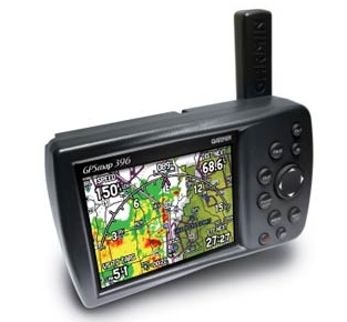
Back on terra firma that night, I found myself wondering if I could justify the cost of acquiring a hand-held GPS receiver with XM weather capability to the Minister of Finance (aka my lovely wife). I've written before about the limitations of on-board radar and XM-provided NEXRAD images, but when the weather is crappy you need all the information you can get. Since on-board radar isn't available, the best I can do right now is check the weather prior to departure, make some educated and conservative guesses about the weather conditions, and talk to flight watch once I'm airborne if things look worse than I expected. So having XM-provided NEXRAD images in flight would be much more desirable than my current situation. The $2000 plus price tag for a Garmin 396 or 496 would be a big hit on our finances and consequently a tough sell.
 So I was interested to learn that Bushnell, a company I've always associated with things like scopes for hunting rifles, has announced a hand-held GPS with WAAS and XM weather capability that is set to list for about $500 when it is released sometime in February of 2007. Sure, there are other XM weather solutions for aviation (pricey PDAs, tablet PCs) and the Bushnell ONIX400CR presumably doesn't know anything about aviation waypoints, VORs, and such. But for the relatively low price, who cares? I've yet to see this unit, but it could be a reasonably-priced alternative to having a pricey Garmin unit. Since most of the aircraft I fly already have panel-mounted, IFR-certified GPS, I would use a unit like this solely for NEXRAD and satellite images.
I'm looking forward to learning more about the ONIX400CR in the coming weeks, Maybe it will come to market in time for Valentine's Day?


