There are many good descriptions of GPS available on line. One of my favorites was authored by Peter H. Dana, The Geographer's Craft Project, Department of Geography, The University of Colorado at Boulder. I'll just mention some highlights.
A constellation of satellites (at least 24, but often more) orbit the earth, broadcasting pseudo-random noise signals that can be received by GPS receivers. The signal from each satellite contains a time stamp and that satellite's position, uploaded to the satellite from a master ground station at Schriever Air Force Base in Colorado. A GPS receiver uses signals from several satellites to calculate a pseudo range (based on the satellite's position and the time it took the signal to reach the receiver, thereby determining its position on earth. GPS receivers should be able to determine your position within about 22 meters 95% of the time.
GPS satellites broadcast two signals, one at 1575.42 MHz and another at 1227.60 MHz. How these signal are designed is beyond the scope of this blog, but each satellite has a unique pseudo-random noise signal code. Consequently each satellite is identified by a PRN number. This is good stuff to know when you see a GPS NOTAM saying a satellite will be unavailable or unreliable. You always request GPS NOTAMs in your pre-flight briefing, right? Here are two GPS NOTAMs that showed up today indicating satellite #6 is out of service and #3 will be out of service on July 17 from 1600 to 2230 Zulu:
GPS 06/040 GPS PRN 6 OTS
GPS 07/009 GPS PRN 3 OTS WEF 0607171600-0607172230
GPS signals are subject to several sources of errors. Ionospheric delay, multi-path errors, clock errors, and insufficient satellites in view are some of the errors that can occur. IFR-certified GPS receivers use an on-going process called RAIM to determine the accuracy of their calculated position. A minimum of 5 satellites must be in view for the receiver to perform a RAIM calculation. 6 satellites are required if a corrupt satellite is to be identified and removed from the calculation of a navigation solution. The GPS receiver regularly calculates two separate navigation solutions based on two unique sets of satellites. It compares the results and if the two solutions differ by more than an allowable amount, the receiver displays a RAIM failure message. A RAIM failure in flight means that the GPS receiver cannot guarantee the accuracy of the position it is reporting and the pilot should use an alternate means of navigation. If a RAIM failure occurs during a GPS approach prior to the final approach fix, the pilot must fly the missed approach and begin navigating by alternate means as soon as practicable.
IFR-certified GPS receivers also provide a RAIM prediction function that pilots should use prior to departing and before arrival. The RAIM prediction simply determines if enough GPS satellites should be in view at a specified location and time. You can do a RAIM prediction for your departure airport and for your arrival airport at your estimated time of arrival. You can also ask Flight Service for a RAIM prediction for your arrival airport. It's important to remember that this is simply a predictionand does not guarantee that a RAIM failure will not occur.
Buried in the AIM, 1-1-19-f(b)7 (emphasis mine), is one of several recommendations that pilots perform a RAIM prediction.
Procedures must be established for use in the event that GPS integrity outages are predicted or occur (RAIM annunciation) ...
AIM section 1-1-19-J also addresses RAIM for GPS approaches and departures:
... Antenna location on the aircraft, satellite position relative to the horizon, and aircraft attitude may affect reception of one or more satellites. Since the relative positions of the satellites are constantly changing, prior experience with the airport does not guarantee reception at all times, and RAIM availability should always be checked.
The WAAS (Wide-Area Augmentation System) uses a set of land-based stations to calculate corrections for ionospheric delay and solar activity, making WAAS-enabled GPS receivers even more accurate. The correction messages are uploaded from a ground master station to a GPS satellite and broadcast to WAAS-enabled receivers, thereby improving accuracy to within about 3 meters. WAAS has it's own set of reliability issues, including one or more ground stations being out of service and insufficient satellites in view. There is currently only one widely available IFR-certified WAAS GPS receiver - the GNS480.
A WAAS-enabled GPS receiver does integrity monitoring and if it discovers an inconsistency in a navigation solution, it is allowed six seconds to determine a correction. If the GPS receiver cannot correct the problem within six seconds, it notifies the user that the position it is reporting is unreliable.
A WAAS service volume model was created to forecast the accuracy of WAAS in terminal areas or larger geographic areas. Since WAAS is used to provide LPV approaches (Localizer-precision with Vertical Guidance), pilots planning to utilize such approaches should check for NOTAMs that indicate whether or not WAAS reliability will be available when they plan to arrive and begin an approach. Here's a WAAS NOTAM that appeared today for the Napa airport:
APC 07/034 APC WAAS LNAV/VNAV AND LPV MNM UNREL WEF 0607180554-0607180609
I have witnessed about a dozen GPS failures in the last 4 years. One occurred in a Caravan I was flying in IMC at a critical moment. The GPS began showing my ground track as being about 30˚ right of my actual course. I was a bit flummoxed at first, but after cross-checking my HSI, magnetic compass, and right side heading indicator, I quickly realized that the GPS was wrong. A few seconds later, a RAIM calculation error message was displayed and the GPS gave up trying to display anything. A few minutes later, the GPS started working again only to fail again after a minute or so. The company's solution to this was to replace the GPS receiver with a brand new one and that cured the problem.
About a month ago, I saw a RAIM failure message in a G1000-equipped plane while my student was flying the missed approach procedure from the Rio Vista GPS RWY 25 approach. We were in visual conditions and it was a practice approach, so we continued to navigate with the GPS to the missed approach holding waypoint. The G1000 provided accuracte navigation to the MAHWP, but when we arrived the G1000 actually told us to do a parallel entry when a direct entry was obviously called for. The GPS was clearly confused and we never determined why. I tried to report the anomoly to NORCAL and got a yes dear, why don't you call flight service and tell someone who cares sort of response.
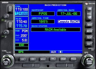
To do a RAIM calculation on a Garmin 430 or 530, scroll with the big knob on the lower right to the AUX pages, scroll with the small knob until you see the page with RAIM, enter cursor mode by pressing the small knob, scroll down to RAIM, and press ENTER. Now you can selet the position and time (or use the present position and current time), then press ENTER to do a RAIM calculation They don't make it easy, do they? No wonder most pilots don't do a RAIM predicition. Oh, and to get out, press the cursor knob twice, then scroll back to the NAV pages with the big knob.

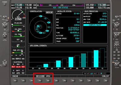
On the G1000, scroll with the big knob on the lower right to reach the system pages, scroll with the small knob until you locate the RAIM feature, press the small knob to enter cursor mode, and select the appropriate position and time. Then press ENTER. Just a convoluted as the 530/430, eh? Note that you can select GPS1 or GPS2 - there are two separate GPS receivers, though this is transparent to G1000 users most of the time.

With the GNS 480, things are much simpler. From the NAV display, press the INFO button, select RAIM, press ENTER. Piece of cake.

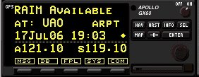
The RAIM feature in the older Apollo GX60 series is also pretty simple to use. From the NAV display, turn the large nob. Simple as pie.

The moral of the story is that GPS is a great tool, but, like any other navigational system, it has limitations. GPS receivers can and do fail, so pilots should understand the limitations of GPS, know how to do a RAIM prediction, and be prepared to use alternate navigational means should the magic box quit working.


