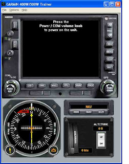
 A reader recently did me a big favor and pointed me to Garmin's newly released PC-based 400/500W GPS Trainer software. As soon as I found time, I did the sensible thing and downloaded the new Trainer and started playing with it. You should, too. Here's why.
This free Trainer software allows you to simulate any of the new WAAS-certified 400 or 500 series GPS units which are approved as a sole means of navigation. You can also select to simulate terrain awareness (TAWS). The sim has a relatively new GPS database and will let you experiment with flying RNAV approaches. The trainer software also plays an important role for pilots who purchase or use the actual WAAS-enabled 400/500 GPS units because it provides an FDE application, which stands for Fault Detection and Exclusion. FDE will become an important part of the preflight planning chores for pilots using one of these units in a real aircraft. More on FDE after reviewing some few pointers on setting up the Trainer.
And let me say "Kudos!" to the folks at Garmin for providing this Trainer free of charge. This is some of the best marketing imaginable, especially since the Trainer is infinitely more useful and usable that their G1000 trainer.
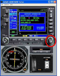
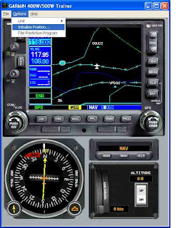
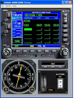
When you first start the trainer, you'll see a window like the one shown at the top of this blog entry. Use the Options pull-down menu, select Unit, and then choose the type of GPS you wish to simulate. I chose the 500 series with TAWS because the 500 has a larger screen and can display more data fields on the two moving map views it provides. Power up the unit by clicking on the communications volume knob. You'll see the unit comes alive thinking you are somewhere in Kansas. I selected the Options->Initialize Position menu item and used the large and small GPS knobs on the lower right side to enter KOAK (Metropolitan Oakland International Airport) as my position, since I live, work, and fly in Northern California
You may recall me complaining that it seemed that pilots flying RNAV approaches with one of these WAAS-certified units would need to be prepared to fly the approach to two or three different minima, based on the GPS accuracy available at the time the approach is commenced. Well the FDE application takes some of the sting out of this by providing a prediction of the sort of GPS course accuracy you can expect, based on the date and time of your flight, your departure, your route, your destination, and your phase of flight. In fact, if you plan to use one of these WAAS-certified receivers as your sole means of navigation (oceanic flight, more that 200 nautical miles from any airport), you must use the FDE prediction application prior to beginning your flight.
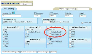
But even those of us flying RNAV SIDs, STARs, and approaches should consider making FDE prediction part of our pre-flight planning when possible. More on the implications of this requirement in a bit. At the very least, make sure you obtain GPS NOTAMs during your pre-flight briefing, such as choosing the DUAT option shown here.
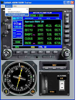
To use the Trainer's FDE prediction application, you first need to enter a flight plan into the unit. So I created a simple flight plan from Oakland to the Byron Airport, about 30 nautical miles to the east. I chose Byron because they have a recently updated RNAV approach with published LPV minima. After entering the flight plan, I pressed the PROC button and loaded the RNAV RWY 30 approach with SHARR intersection as the IAF. In real life, it is unlikely that ATC would let you proceed to directly to SHARR as a transition when approaching from the west, but I was just simulating.
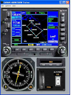
With a flight plan entered and approach loaded (but not activated), you can launch the FDE program using the Options->Fde Prediction Program menu item. For me, this resulted in a series of dialogs telling me that the GEO almanac and the configuration file were corrupt or out of date. Each dialog gave me the option of downloading the current almanac and configuration file, so one assumes, and this is important, that a valid internet connection is required to use the trainer's FDE features.
Finally, the WFDE prediction program was launched providing more options. One option allows you to select the GPS antenna in your aircraft. I actually don't know what sort of antenna might be installed on the average GA aircraft, so I just left it on the default A-33 model. You can also specify your departure date and time. Finally there is a Setup button, which you should click on before clicking on the Calculate button.
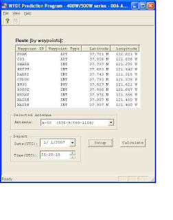
The Setup option lets you specify some important facts concerning your flight, like the estimated ground speed, the type of route, such as Oceanic, EnRoute/Terminal, etc.
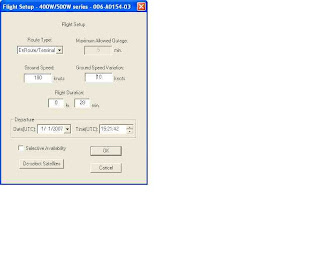
Now click on Okay, then Calculate, and the FDE application comes back with a display telling you if GPS is available for your route and whether RAIM and FDE are available. The program also tells you which RNAV approach minima you can use for planning purposes, though this is not a guarantee that the lowest minima will be available when you actually arrive.
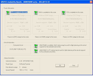
So what's the big deal about FDE, you ask? Here's some guidance from the Garmin 530W Pilot Guide and Reference (with hyperlink added by me):
The Garmin 500W-series software incorporates a Fault Detection and Exclusion (FDE) algorithm, thus providing a basis for approval per FAA Notice N8110.60 requirements for "GPS as a Primary Means of Navigation for Oceanic/Remote Operations."The WFDE Prediction Program Instructions go on to clarify what an operator (or pilot) must do if they plan to use the unit to fly RNAV routes, departures or approaches (again, hyperlinks added by me).
The FDE consists of two distinct features, fault detection and fault exclusion. The fault detection feature detects the presence of an unacceptably large pseudorange error for a satellite (and presumable, position error) for a given mode of flight. Upon detection, fault exclusion follows and excludes the source of the unacceptably large pseudorange error, thereby allowing navigation to return to normal performance without an interruption in service. To enhance safety, FDE functionality is provided for other phases of flight (non-precision approach, terminal, en route). The FDE functionality for non-oceanic flight phases complies with missed alert probability, false alert probability, and failed exclusion probability specified by DO-229C/TSO-146a.
Prior to navigation on U.S. RNAV routes. SIDs, and STARs (reference AC 91-100) all operation of Garmin WAAS-certified units must utilize the WFDE Prediction Program to determine RAIM availability.To my mind, this means that prior to departure you'll want to have access to a computer that has the Trainer software loaded and that computer will need to have an internet connection. Ideally, you'll want run the FDE prediction application before you fly if you plan to use a 400W/500W series GPS for LNAV/VNAV or LPV approaches, though this might not always be practical.
All operators of Garmin WAAS-certified units should utilize the WFDE Prediction Program to determine WAAS satellite visibility when planning an LNAV/VNAV or LPV approach.
In the next installment, I'll detail some simulated RNAV approach adventures using the Trainer software.


